Airway Heights geodata
Airway Heights (Washington) is a populated place; located in United States in America/Los_Angeles (GMT-7) time zone. With population of 6,639 people, there are 6031 cities with bigger population in this country. Compared to other cities in United States, 98% of cities are located further ↓South; 90.4% of cities are located further →East and 91.2% of cities have lower elevation than Airway Heights. Note1


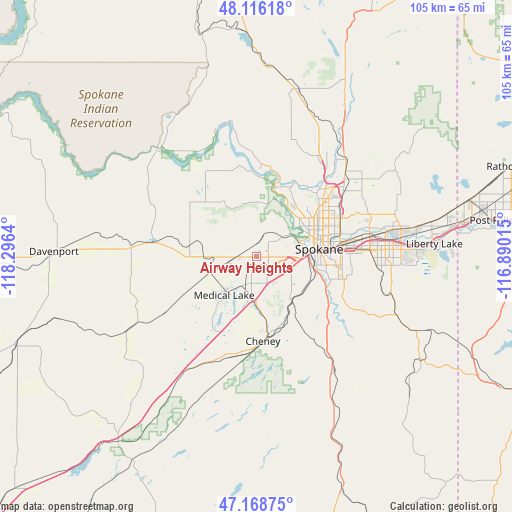
Airway Heights GPS coordinates[2]
47° 38' 40.596" North, 117° 35' 35.772" West
| Map corner | latitude | longitude |
|---|---|---|
| Upper-left | 48.11618°, | -118.2964° |
| Center: | 47.64461°, | -117.59327° |
| Lower-right: | 47.16875°, | -116.89015° |
| Map W x H: | 105.3×105.3 km | = 65.4×65.4mi |
| max Lat: | 71.29058° ⇑2% North |
| Airway Heights: | 47.64461° |
| min Lat: | ⇓98% South 19.06759° |
| min Long | Airway Heights | max Long |
| -171.73463° | -117.59327° | -66.98998° |
| W 9.6%⇐ | ⇒90.4% E |
Elevation
Elevation of Airway Heights is 730 m = 2395 ft, and this is 435.2 m = 1428 ft above average elevation for this country.
| Max E: |
3189 m = 10463 ft | 8.8% |
| Airway Heights | 730 m 2395 ft | |
| Avg. | 294.8 m = 967 ft | |
Min E: |
-60 m = -197 ft | 91.2% |
See also: United States elevation on elevation.city.
Geographical zone
Airway Heights is located in North temperate zone (between Tropic of Cancer and the Arctic Circle). Distance of this North polar circle is 2103.6 km =1307.1 mi to North.| Distance of | km | miles | from Airway Heights |
|---|---|---|---|
| North Pole | 4709.5 | 2926.3 | to North |
| Arctic Circle | 2103.6 | 1307.1 | to North |
| Tropic Cancer | 2691.7 | 1672.5 | to South |
| Equator | 5297.6 | 3291.8 | to South |


Nearby cities:
15 places around Airway Heights: (largest is in red/bold)
• Cheney
17.5 km =10.9 mi,  175°
175°
• Country Homes
18.3 km =11.4 mi,  50°
50°
• Dishman
23.8 km =14.8 mi,  85°
85°
• Fairchild Air Force Base
5 km =3.1 mi,  235°
235°
• Fairwood
18.9 km =11.7 mi,  44°
44°
• Four Lakes
9.3 km =5.8 mi, 180°
• Mead
22.5 km =14 mi, 52°
• Medical Lake
10.4 km =6.5 mi,  219°
219°
• Millwood
23.6 km =14.7 mi,  80°
80°
• Opportunity
26.5 km =16.5 mi, 88°
• Reardan
21.5 km =13.4 mi,  277°
277°
• Spokane
12.4 km =7.7 mi, 82°
• Spokane Valley
26.7 km =16.6 mi, 83°
• Town and Country
15.8 km =9.8 mi, 54°
• Veradale
28.9 km =18 mi, 88°
Sources, notices
• [Note1] Compared only with cities in United States existing in our database
• [Src1] Map data: © OpenStreetMap contributors (CC-BY-SA)
• [Src2] Other city data from geonames.org with taken over terms of usage.
• [Src3] Geographical zone / Annual Mean Temperature by Robert A. Rohde @ Wikipedia
