Country Homes geodata
Country Homes (Washington) is a populated place; located in United States in America/Los_Angeles (GMT-7) time zone. With population of 5,841 people, there are 6515 cities with bigger population in this country. Compared to other cities in United States, 98.2% of cities are located further ↓South; 90.3% of cities are located further →East and 89.6% of cities have lower elevation than Country Homes. Note1


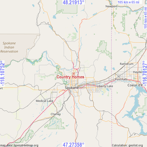
Country Homes GPS coordinates[2]
47° 44' 54.6" North, 117° 24' 15.804" West
| Map corner | latitude | longitude |
|---|---|---|
| Upper-left | 48.21913°, | -118.10752° |
| Center: | 47.7485°, | -117.40439° |
| Lower-right: | 47.27358°, | -116.70127° |
| Map W x H: | 105.1×105.1 km | = 65.3×65.3mi |
| max Lat: | 71.29058° ⇑1.8% North |
| Country Homes: | 47.7485° |
| min Lat: | ⇓98.2% South 19.06759° |
| min Long | Country Homes | max Long |
| -171.73463° | -117.40439° | -66.98998° |
| W 9.7%⇐ | ⇒90.3% E |
Elevation
Elevation of Country Homes is 593 m = 1946 ft, and this is 298.2 m = 978 ft above average elevation for this country.
| Max E: |
3189 m = 10463 ft | 10.4% |
| Country Homes | 593 m 1946 ft | |
| Avg. | 294.8 m = 967 ft | |
Min E: |
-60 m = -197 ft | 89.6% |
See also: United States elevation on elevation.city.
Geographical zone
Country Homes is located in North temperate zone (between Tropic of Cancer and the Arctic Circle). Distance of this North polar circle is 2092 km =1299.9 mi to North.| Distance of | km | miles | from Country Homes |
|---|---|---|---|
| North Pole | 4697.9 | 2919.1 | to North |
| Arctic Circle | 2092 | 1299.9 | to North |
| Tropic Cancer | 2703.2 | 1679.7 | to South |
| Equator | 5309.1 | 3298.9 | to South |


Nearby cities:
15 places around Country Homes: (largest is in red/bold)
• Airway Heights
18.3 km =11.4 mi,  230°
230°
• Deer Park
23.5 km =14.6 mi,  346°
346°
• Dishman
13.7 km =8.5 mi,  135°
135°
• Fairchild Air Force Base
23.3 km =14.5 mi, 231°
• Fairwood
2.3 km =1.4 mi,  334°
334°
• Green Bluff
13.2 km =8.2 mi,  48°
48°
• Liberty Lake
22.9 km =14.2 mi,  110°
110°
• Mead
4.3 km =2.7 mi,  60°
60°
• Millwood
11.8 km =7.3 mi,  129°
129°
• Opportunity
16.5 km =10.3 mi, 131°
• Spokane
10 km =6.2 mi,  190°
190°
• Spokane Valley
14.9 km =9.3 mi,  124°
124°
• Town and Country
2.7 km =1.7 mi,  208°
208°
• Trentwood
15.6 km =9.7 mi, 111°
• Veradale
18.4 km =11.4 mi, 126°
Sources, notices
• [Note1] Compared only with cities in United States existing in our database
• [Src1] Map data: © OpenStreetMap contributors (CC-BY-SA)
• [Src2] Other city data from geonames.org with taken over terms of usage.
• [Src3] Geographical zone / Annual Mean Temperature by Robert A. Rohde @ Wikipedia
