Spokane geodata
Spokane (Washington) is a seat of a second-order administrative division; located in United States in America/Los_Angeles (GMT-7) time zone. With population of 213,272 people, there are 112 cities with bigger population in this country. Compared to other cities in United States, 98% of cities are located further ↓South; 90.3% of cities are located further →East and 88.5% of cities have lower elevation than Spokane. Note1


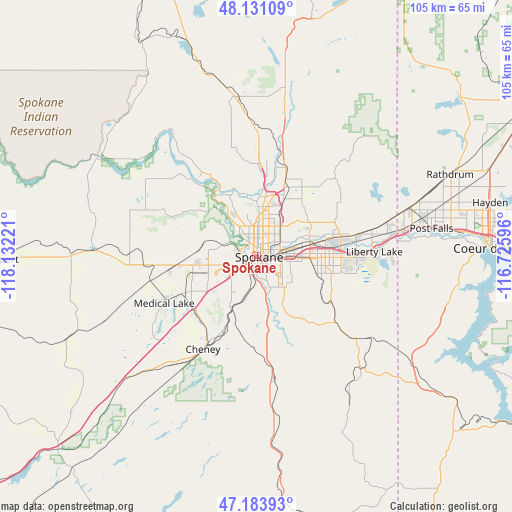
Spokane GPS coordinates[2]
47° 39' 34.776" North, 117° 25' 44.688" West
| Map corner | latitude | longitude |
|---|---|---|
| Upper-left | 48.13109°, | -118.13221° |
| Center: | 47.65966°, | -117.42908° |
| Lower-right: | 47.18393°, | -116.72596° |
| Map W x H: | 105.3×105.3 km | = 65.4×65.4mi |
| max Lat: | 71.29058° ⇑2% North |
| Spokane: | 47.65966° |
| min Lat: | ⇓98% South 19.06759° |
| min Long | Spokane | max Long |
| -171.73463° | -117.42908° | -66.98998° |
| W 9.7%⇐ | ⇒90.3% E |
Elevation
Elevation of Spokane is 530 m = 1739 ft, and this is 235.2 m = 772 ft above average elevation for this country.
| Max E: |
3189 m = 10463 ft | 11.5% |
| Spokane | 530 m 1739 ft | |
| Avg. | 294.8 m = 967 ft | |
Min E: |
-60 m = -197 ft | 88.5% |
See also: Spokane elevation on elevation.city.
Geographical zone
Spokane is located in North temperate zone (between Tropic of Cancer and the Arctic Circle). Distance of this North polar circle is 2101.9 km =1306.1 mi to North.| Distance of | km | miles | from Spokane |
|---|---|---|---|
| North Pole | 4707.8 | 2925.3 | to North |
| Arctic Circle | 2101.9 | 1306.1 | to North |
| Tropic Cancer | 2693.3 | 1673.5 | to South |
| Equator | 5299.3 | 3292.8 | to South |


Nearby cities:
15 places around Spokane: (largest is in red/bold)
• Airway Heights
12.4 km =7.7 mi,  262°
262°
• Country Homes
10 km =6.2 mi,  10°
10°
• Dishman
11.5 km =7.1 mi,  89°
89°
• Fairchild Air Force Base
17 km =10.6 mi,  254°
254°
• Fairwood
11.9 km =7.4 mi,  4°
4°
• Four Lakes
16.5 km =10.3 mi,  228°
228°
• Green Bluff
22.1 km =13.7 mi,  32°
32°
• Mead
13.2 km =8.2 mi,  24°
24°
• Medical Lake
21.3 km =13.2 mi,  243°
243°
• Millwood
11.2 km =7 mi,  77°
77°
• Opportunity
14.2 km =8.8 mi, 94°
• Spokane Valley
14.3 km =8.9 mi, 83°
• Town and Country
7.6 km =4.7 mi, 4°
• Trentwood
16.9 km =10.5 mi, 75°
• Veradale
16.6 km =10.3 mi, 93°
Sources, notices
• [Note1] Compared only with cities in United States existing in our database
• [Src1] Map data: © OpenStreetMap contributors (CC-BY-SA)
• [Src2] Other city data from geonames.org with taken over terms of usage.
• [Src3] Geographical zone / Annual Mean Temperature by Robert A. Rohde @ Wikipedia
