East Renton Highlands geodata
East Renton Highlands (Washington) is a populated place; located in United States in America/Los_Angeles (GMT-7) time zone. With population of 11,140 people, there are 4141 cities with bigger population in this country. Compared to other cities in United States, 97.6% of cities are located further ↓South; 95.4% of cities are located further →East and 58% of cities have higher elevation than East Renton Highlands. Note1
Current local time in East Renton Highlands:
12:53 AM, WednesdayDifference from your time zone: hours


East Renton Highlands GPS coordinates[2]
47° 29' 5.352" North, 122° 6' 44.424" West
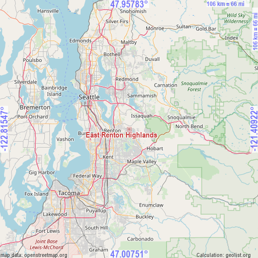
| Map corner | latitude | longitude |
|---|---|---|
| Upper-left | 47.95783°, | -122.81547° |
| Center: | 47.48482°, | -122.11234° |
| Lower-right: | 47.00751°, | -121.40922° |
| Map W x H: | 105.7×105.7 km | = 65.7×65.7mi |
| max Lat: | 71.29058° ⇑2.4% North |
| East Renton Highlands: | 47.48482° |
| min Lat: | ⇓97.6% South 19.06759° |
| min Long | East Renton Hig | max Long |
| -171.73463° | -122.11234° | -66.98998° |
| W 4.6%⇐ | ⇒95.4% E |
Elevation
Elevation of East Renton Highlands is 165 m = 541 ft, and this is 129.8 m = 426 ft below average elevation for this country.
| Max E: |
3189 m = 10463 ft | 58% |
| Avg. | 294.8 m = 967 ft | |
| East Renton Highlands | 165 m = 541 ft | |
Min E: |
-60 m = -197 ft | 42% |
See also: United States elevation on elevation.city.
Geographical zone
East Renton Highlands is located in North temperate zone (between Tropic of Cancer and the Arctic Circle). Distance of this North polar circle is 2121.4 km =1318.2 mi to North.| Distance of | km | miles | from East Renton Highlands |
|---|---|---|---|
| North Pole | 4727.2 | 2937.3 | to North |
| Arctic Circle | 2121.4 | 1318.2 | to North |
| Tropic Cancer | 2673.9 | 1661.5 | to South |
| Equator | 5279.8 | 3280.7 | to South |


Nearby cities:
15 places around East Renton Highlands: (largest is in red/bold)
• Bryn Mawr-Skyway
9.7 km =6 mi,  276°
276°
• East Hill-Meridian
9.5 km =5.9 mi,  209°
209°
• Eastgate
10.1 km =6.3 mi,  345°
345°
• Fairwood
5.3 km =3.3 mi,  219°
219°
• Hobart
12.6 km =7.8 mi,  123°
123°
• Issaquah
7.8 km =4.8 mi,  49°
49°
• Klahanie
12.4 km =7.7 mi,  39°
39°
• Maple Heights-Lake Desire
4.7 km =2.9 mi,  166°
166°
• Maple Valley
11.4 km =7.1 mi,  154°
154°
• Mirrormont
9.1 km =5.7 mi,  105°
105°
• Newcastle
6.8 km =4.2 mi,  331°
331°
• Newport
10.9 km =6.8 mi, 331°
• Renton
7.9 km =4.9 mi,  268°
268°
• Tukwila
11.2 km =7 mi,  263°
263°
• West Lake Sammamish
10.3 km =6.4 mi,  4°
4°
Sources, notices
• [Note1] Compared only with cities in United States existing in our database
• [Src1] Map data: © OpenStreetMap contributors (CC-BY-SA)
• [Src2] Other city data from geonames.org with taken over terms of usage.
• [Src3] Geographical zone / Annual Mean Temperature by Robert A. Rohde @ Wikipedia
