East Hill-Meridian geodata
East Hill-Meridian (Washington) is a populated place; located in United States in America/Los_Angeles (GMT-7) time zone. With population of 29,878 people, there are 1669 cities with bigger population in this country. Compared to other cities in United States, 97.4% of cities are located further ↓South; 95.5% of cities are located further →East and 59.7% of cities have higher elevation than East Hill-Meridian. Note1


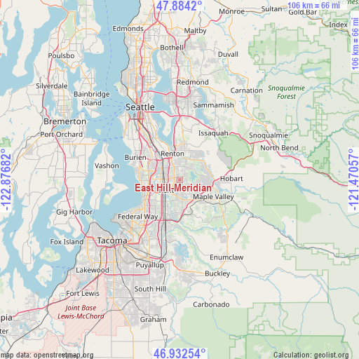
East Hill-Meridian GPS coordinates[2]
47° 24' 37.872" North, 122° 10' 25.284" West
| Map corner | latitude | longitude |
|---|---|---|
| Upper-left | 47.8842°, | -122.87682° |
| Center: | 47.41052°, | -122.17369° |
| Lower-right: | 46.93254°, | -121.47057° |
| Map W x H: | 105.8×105.8 km | = 65.7×65.7mi |
| max Lat: | 71.29058° ⇑2.6% North |
| East Hill-Meridian: | 47.41052° |
| min Lat: | ⇓97.4% South 19.06759° |
| min Long | East Hill-Merid | max Long |
| -171.73463° | -122.17369° | -66.98998° |
| W 4.5%⇐ | ⇒95.5% E |
Elevation
Elevation of East Hill-Meridian is 156 m = 512 ft, and this is 138.8 m = 455 ft below average elevation for this country.
| Max E: |
3189 m = 10463 ft | 59.7% |
| Avg. | 294.8 m = 967 ft | |
| East Hill-Meridian | 156 m = 512 ft | |
Min E: |
-60 m = -197 ft | 40.3% |
See also: United States elevation on elevation.city.
Geographical zone
East Hill-Meridian is located in North temperate zone (between Tropic of Cancer and the Arctic Circle). Distance of this North polar circle is 2129.6 km =1323.3 mi to North.| Distance of | km | miles | from East Hill-Meridian |
|---|---|---|---|
| North Pole | 4735.5 | 2942.5 | to North |
| Arctic Circle | 2129.6 | 1323.3 | to North |
| Tropic Cancer | 2665.6 | 1656.3 | to South |
| Equator | 5271.6 | 3275.6 | to South |


Nearby cities:
15 places around East Hill-Meridian: (largest is in red/bold)
• Auburn
12.2 km =7.6 mi,  199°
199°
• Bryn Mawr-Skyway
10.6 km =6.6 mi,  331°
331°
• Covington
7 km =4.3 mi,  146°
146°
• Des Moines
11.4 km =7.1 mi,  265°
265°
• East Renton Highlands
9.5 km =5.9 mi,  29°
29°
• Fairwood
4.4 km =2.7 mi,  16°
16°
• Kent
5.7 km =3.5 mi,  234°
234°
• Lake Morton-Berrydale
10.2 km =6.3 mi, 148°
• Lakeland North
11.6 km =7.2 mi,  222°
222°
• Lea Hill
9.4 km =5.8 mi,  183°
183°
• Maple Heights-Lake Desire
6.9 km =4.3 mi,  56°
56°
• Maple Valley
9.8 km =6.1 mi,  101°
101°
• Renton
8.7 km =5.4 mi,  337°
337°
• SeaTac
9.9 km =6.2 mi,  295°
295°
• Tukwila
9.6 km =6 mi,  317°
317°
Sources, notices
• [Note1] Compared only with cities in United States existing in our database
• [Src1] Map data: © OpenStreetMap contributors (CC-BY-SA)
• [Src2] Other city data from geonames.org with taken over terms of usage.
• [Src3] Geographical zone / Annual Mean Temperature by Robert A. Rohde @ Wikipedia
