Renton geodata
Renton (Washington) is a populated place; located in United States in America/Los_Angeles (GMT-7) time zone. With population of 100,242 people, there are 348 cities with bigger population in this country. Compared to other cities in United States, 97.6% of cities are located further ↓South; 95.7% of cities are located further →East and 91.5% of cities have higher elevation than Renton. Note1


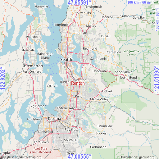
Renton GPS coordinates[2]
47° 28' 58.368" North, 122° 13' 1.452" West
| Map corner | latitude | longitude |
|---|---|---|
| Upper-left | 47.95591°, | -122.9202° |
| Center: | 47.48288°, | -122.21707° |
| Lower-right: | 47.00555°, | -121.51395° |
| Map W x H: | 105.7×105.7 km | = 65.7×65.7mi |
| max Lat: | 71.29058° ⇑2.4% North |
| Renton: | 47.48288° |
| min Lat: | ⇓97.6% South 19.06759° |
| min Long | Renton | max Long |
| -171.73463° | -122.21707° | -66.98998° |
| W 4.3%⇐ | ⇒95.7% E |
Elevation
Elevation of Renton is 13 m = 43 ft, and this is 281.8 m = 925 ft below average elevation for this country.
| Max E: |
3189 m = 10463 ft | 91.5% |
| Avg. | 294.8 m = 967 ft | |
| Renton | 13 m = 43 ft | |
Min E: |
-60 m = -197 ft | 8.5% |
See also: Renton elevation on elevation.city.
Geographical zone
Renton is located in North temperate zone (between Tropic of Cancer and the Arctic Circle). Distance of this North polar circle is 2121.6 km =1318.3 mi to North.| Distance of | km | miles | from Renton |
|---|---|---|---|
| North Pole | 4727.5 | 2937.5 | to North |
| Arctic Circle | 2121.6 | 1318.3 | to North |
| Tropic Cancer | 2673.7 | 1661.4 | to South |
| Equator | 5279.6 | 3280.6 | to South |


Nearby cities:
15 places around Renton: (largest is in red/bold)
• Boulevard Park
7.4 km =4.6 mi,  275°
275°
• Bryn Mawr-Skyway
2.2 km =1.4 mi,  305°
305°
• Burien
9.8 km =6.1 mi,  261°
261°
• East Hill-Meridian
8.7 km =5.4 mi,  157°
157°
• East Renton Highlands
7.9 km =4.9 mi,  88°
88°
• Fairwood
5.9 km =3.7 mi,  130°
130°
• Maple Heights-Lake Desire
10 km =6.2 mi,  115°
115°
• Mercer Island
9.8 km =6.1 mi,  357°
357°
• Newcastle
7.8 km =4.8 mi,  36°
36°
• Newport
10.2 km =6.3 mi,  15°
15°
• Normandy Park
10.6 km =6.6 mi,  240°
240°
• Riverton
5.8 km =3.6 mi,  271°
271°
• SeaTac
6.8 km =4.2 mi, 235°
• Tukwila
3.4 km =2.1 mi,  253°
253°
• White Center
11 km =6.8 mi,  290°
290°
Sources, notices
• [Note1] Compared only with cities in United States existing in our database
• [Src1] Map data: © OpenStreetMap contributors (CC-BY-SA)
• [Src2] Other city data from geonames.org with taken over terms of usage.
• [Src3] Geographical zone / Annual Mean Temperature by Robert A. Rohde @ Wikipedia
