Everett geodata
Everett (Washington) is a seat of a second-order administrative division; located in United States in America/Los_Angeles (GMT-7) time zone. With population of 108,010 people, there are 315 cities with bigger population in this country. Compared to other cities in United States, 98.6% of cities are located further ↓South; 95.7% of cities are located further →East and 87.4% of cities have higher elevation than Everett. Note1


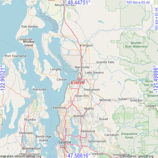
Everett GPS coordinates[2]
47° 58' 44.328" North, 122° 12' 7.488" West
| Map corner | latitude | longitude |
|---|---|---|
| Upper-left | 48.44751°, | -122.90521° |
| Center: | 47.97898°, | -122.20208° |
| Lower-right: | 47.50616°, | -121.49896° |
| Map W x H: | 104.7×104.7 km | = 65.1×65.1mi |
| max Lat: | 71.29058° ⇑1.4% North |
| Everett: | 47.97898° |
| min Lat: | ⇓98.6% South 19.06759° |
| min Long | Everett | max Long |
| -171.73463° | -122.20208° | -66.98998° |
| W 4.3%⇐ | ⇒95.7% E |
Elevation
Elevation of Everett is 22 m = 72 ft, and this is 272.8 m = 895 ft below average elevation for this country.
| Max E: |
3189 m = 10463 ft | 87.4% |
| Avg. | 294.8 m = 967 ft | |
| Everett | 22 m = 72 ft | |
Min E: |
-60 m = -197 ft | 12.6% |
See also: Everett elevation on elevation.city.
Geographical zone
Everett is located in North temperate zone (between Tropic of Cancer and the Arctic Circle). Distance of this North polar circle is 2066.4 km =1284 mi to North.| Distance of | km | miles | from Everett |
|---|---|---|---|
| North Pole | 4672.3 | 2903.2 | to North |
| Arctic Circle | 2066.4 | 1284 | to North |
| Tropic Cancer | 2728.8 | 1695.6 | to South |
| Equator | 5334.8 | 3314.9 | to South |


Nearby cities:
15 places around Everett: (largest is in red/bold)
• Bunk Foss
8.2 km =5.1 mi,  103°
103°
• Clinton
11.4 km =7.1 mi,  269°
269°
• Eastmont
9.2 km =5.7 mi,  170°
170°
• Fobes Hill
7 km =4.3 mi,  118°
118°
• Lake Stevens
11 km =6.8 mi,  68°
68°
• Lake Stickney
12.2 km =7.6 mi,  201°
201°
• Machias
11.6 km =7.2 mi,  88°
88°
• Marysville
8.3 km =5.2 mi,  12°
12°
• Mukilteo
8.5 km =5.3 mi,  243°
243°
• Priest Point
7.4 km =4.6 mi,  330°
330°
• Shaker Church
8.4 km =5.2 mi,  346°
346°
• Snohomish
10.7 km =6.6 mi,  133°
133°
• Tulalip
12 km =7.5 mi, 326°
• Tulalip Bay
10.3 km =6.4 mi,  308°
308°
• West Lake Stevens
7.6 km =4.7 mi,  77°
77°
Sources, notices
• [Note1] Compared only with cities in United States existing in our database
• [Src1] Map data: © OpenStreetMap contributors (CC-BY-SA)
• [Src2] Other city data from geonames.org with taken over terms of usage.
• [Src3] Geographical zone / Annual Mean Temperature by Robert A. Rohde @ Wikipedia
