Marysville geodata
Marysville (Washington) is a populated place; located in United States in America/Los_Angeles (GMT-7) time zone. With population of 66,773 people, there are 636 cities with bigger population in this country. Compared to other cities in United States, 98.7% of cities are located further ↓South; 95.6% of cities are located further →East and 97.4% of cities have higher elevation than Marysville. Note1


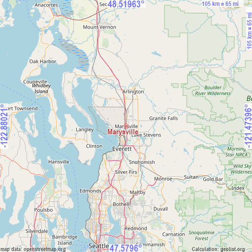
Marysville GPS coordinates[2]
48° 3' 6.336" North, 122° 10' 37.488" West
| Map corner | latitude | longitude |
|---|---|---|
| Upper-left | 48.51963°, | -122.88021° |
| Center: | 48.05176°, | -122.17708° |
| Lower-right: | 47.5796°, | -121.47396° |
| Map W x H: | 104.5×104.5 km | = 64.9×64.9mi |
| max Lat: | 71.29058° ⇑1.3% North |
| Marysville: | 48.05176° |
| min Lat: | ⇓98.7% South 19.06759° |
| min Long | Marysville | max Long |
| -171.73463° | -122.17708° | -66.98998° |
| W 4.4%⇐ | ⇒95.6% E |
Elevation
Elevation of Marysville is 6 m = 20 ft, and this is 288.8 m = 948 ft below average elevation for this country.
| Max E: |
3189 m = 10463 ft | 97.4% |
| Avg. | 294.8 m = 967 ft | |
| Marysville | 6 m = 20 ft | |
Min E: |
-60 m = -197 ft | 2.6% |
See also: Marysville elevation on elevation.city.
Geographical zone
Marysville is located in North temperate zone (between Tropic of Cancer and the Arctic Circle). Distance of this North polar circle is 2058.3 km =1279 mi to North.| Distance of | km | miles | from Marysville |
|---|---|---|---|
| North Pole | 4664.2 | 2898.2 | to North |
| Arctic Circle | 2058.3 | 1279 | to North |
| Tropic Cancer | 2736.9 | 1700.6 | to South |
| Equator | 5342.9 | 3319.9 | to South |


Nearby cities:
15 places around Marysville: (largest is in red/bold)
• Bunk Foss
11.8 km =7.3 mi,  148°
148°
• Cathan
10.2 km =6.3 mi,  313°
313°
• Everett
8.3 km =5.2 mi,  192°
192°
• John Sam Lake
8.2 km =5.1 mi,  321°
321°
• Lake Stevens
9.4 km =5.8 mi,  115°
115°
• Lochsloy
10.8 km =6.7 mi,  90°
90°
• Priest Point
5.7 km =3.5 mi,  253°
253°
• Shaker Church
3.8 km =2.4 mi,  271°
271°
• Sisco Heights
9.2 km =5.7 mi,  40°
40°
• Smokey Point
11.2 km =7 mi,  357°
357°
• Stimson Crossing
7.9 km =4.9 mi, 356°
• Tulalip
8.7 km =5.4 mi,  282°
282°
• Tulalip Bay
10 km =6.2 mi,  260°
260°
• Weallup Lake
11.6 km =7.2 mi,  304°
304°
• West Lake Stevens
8.6 km =5.3 mi,  139°
139°
Sources, notices
• [Note1] Compared only with cities in United States existing in our database
• [Src1] Map data: © OpenStreetMap contributors (CC-BY-SA)
• [Src2] Other city data from geonames.org with taken over terms of usage.
• [Src3] Geographical zone / Annual Mean Temperature by Robert A. Rohde @ Wikipedia
