Shaker Church geodata
Shaker Church (Washington) is a populated place; located in United States in America/Los_Angeles (GMT-7) time zone. With population of 830 people, there are 17521 cities with bigger population in this country. Compared to other cities in United States, 98.7% of cities are located further ↓South; 95.7% of cities are located further →East and 72.3% of cities have higher elevation than Shaker Church. Note1


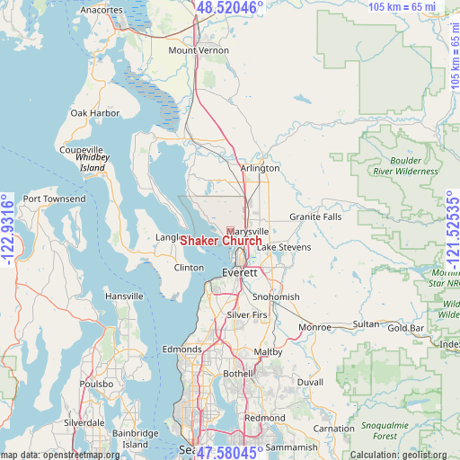
Shaker Church GPS coordinates[2]
48° 3' 9.36" North, 122° 13' 42.492" West
| Map corner | latitude | longitude |
|---|---|---|
| Upper-left | 48.52046°, | -122.9316° |
| Center: | 48.0526°, | -122.22847° |
| Lower-right: | 47.58045°, | -121.52535° |
| Map W x H: | 104.5×104.5 km | = 64.9×64.9mi |
| max Lat: | 71.29058° ⇑1.3% North |
| Shaker Church: | 48.0526° |
| min Lat: | ⇓98.7% South 19.06759° |
| min Long | Shaker Church | max Long |
| -171.73463° | -122.22847° | -66.98998° |
| W 4.3%⇐ | ⇒95.7% E |
Elevation
Elevation of Shaker Church is 87 m = 285 ft, and this is 207.8 m = 682 ft below average elevation for this country.
| Max E: |
3189 m = 10463 ft | 72.3% |
| Avg. | 294.8 m = 967 ft | |
| Shaker Church | 87 m = 285 ft | |
Min E: |
-60 m = -197 ft | 27.7% |
See also: United States elevation on elevation.city.
Geographical zone
Shaker Church is located in North temperate zone (between Tropic of Cancer and the Arctic Circle). Distance of this North polar circle is 2058.2 km =1278.9 mi to North.| Distance of | km | miles | from Shaker Church |
|---|---|---|---|
| North Pole | 4664.1 | 2898.1 | to North |
| Arctic Circle | 2058.2 | 1278.9 | to North |
| Tropic Cancer | 2737 | 1700.7 | to South |
| Equator | 5342.9 | 3319.9 | to South |


Nearby cities:
15 places around Shaker Church: (largest is in red/bold)
• Cathan
7.8 km =4.8 mi,  332°
332°
• Clinton
12.6 km =7.8 mi,  228°
228°
• Everett
8.4 km =5.2 mi,  166°
166°
• John Sam Lake
6.4 km =4 mi,  348°
348°
• Lake Stevens
12.9 km =8 mi,  108°
108°
• Marysville
3.8 km =2.4 mi,  91°
91°
• Mukilteo
13.3 km =8.3 mi,  205°
205°
• Priest Point
2.4 km =1.5 mi,  223°
223°
• Sisco Heights
12 km =7.5 mi,  54°
54°
• Smokey Point
11.6 km =7.2 mi,  17°
17°
• Stimson Crossing
8.5 km =5.3 mi, 23°
• Tulalip
5 km =3.1 mi,  290°
290°
• Tulalip Bay
6.3 km =3.9 mi,  254°
254°
• Weallup Lake
8.6 km =5.3 mi,  317°
317°
• West Lake Stevens
11.5 km =7.1 mi,  124°
124°
Sources, notices
• [Note1] Compared only with cities in United States existing in our database
• [Src1] Map data: © OpenStreetMap contributors (CC-BY-SA)
• [Src2] Other city data from geonames.org with taken over terms of usage.
• [Src3] Geographical zone / Annual Mean Temperature by Robert A. Rohde @ Wikipedia
