Olympia geodata
Olympia (Washington) is a seat of a first-order administrative division; located in United States in America/Los_Angeles (GMT-7) time zone. With population of 50,302 people, there are 943 cities with bigger population in this country. Compared to other cities in United States, 96.7% of cities are located further ↓South; 97.7% of cities are located further →East and 83.8% of cities have higher elevation than Olympia. Note1


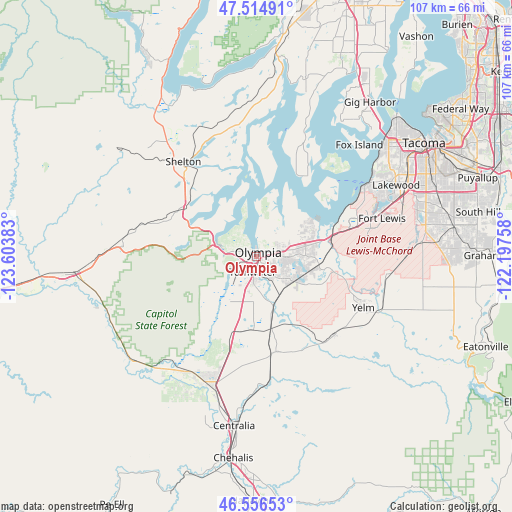
Olympia GPS coordinates[2]
47° 2' 16.332" North, 122° 54' 2.52" West
| Map corner | latitude | longitude |
|---|---|---|
| Upper-left | 47.51491°, | -123.60383° |
| Center: | 47.03787°, | -122.9007° |
| Lower-right: | 46.55653°, | -122.19758° |
| Map W x H: | 106.6×106.6 km | = 66.2×66.2mi |
| max Lat: | 71.29058° ⇑3.3% North |
| Olympia: | 47.03787° |
| min Lat: | ⇓96.7% South 19.06759° |
| min Long | Olympia | max Long |
| -171.73463° | -122.9007° | -66.98998° |
| W 2.3%⇐ | ⇒97.7% E |
Elevation
Elevation of Olympia is 32 m = 105 ft, and this is 262.8 m = 862 ft below average elevation for this country.
| Max E: |
3189 m = 10463 ft | 83.8% |
| Avg. | 294.8 m = 967 ft | |
| Olympia | 32 m = 105 ft | |
Min E: |
-60 m = -197 ft | 16.2% |
See also: Olympia elevation on elevation.city.
Geographical zone
Olympia is located in North temperate zone (between Tropic of Cancer and the Arctic Circle). Distance of this North polar circle is 2171.1 km =1349.1 mi to North.| Distance of | km | miles | from Olympia |
|---|---|---|---|
| North Pole | 4776.9 | 2968.2 | to North |
| Arctic Circle | 2171.1 | 1349.1 | to North |
| Tropic Cancer | 2624.2 | 1630.6 | to South |
| Equator | 5230.1 | 3249.8 | to South |


Nearby cities:
15 places around Olympia: (largest is in red/bold)
• Bucoda
26.7 km =16.6 mi,  174°
174°
• DuPont
21.4 km =13.3 mi,  72°
72°
• Joint Base Lewis McChord
25.7 km =16 mi, 72°
• Lacey
5.9 km =3.7 mi,  93°
93°
• Longbranch
21.9 km =13.6 mi,  29°
29°
• Nisqually Indian Community
16.1 km =10 mi, 94°
• North Fort Lewis
25 km =15.5 mi, 68°
• North Yelm
24.1 km =15 mi,  110°
110°
• Rainier
23.2 km =14.4 mi,  135°
135°
• Shelton
24.8 km =15.4 mi,  322°
322°
• Tanglewilde
9.1 km =5.7 mi,  80°
80°
• Tanglewilde-Thompson Place
9.2 km =5.7 mi, 80°
• Tenino
20.5 km =12.7 mi, 169°
• Tumwater
3.5 km =2.2 mi,  190°
190°
• Yelm
24.8 km =15.4 mi,  115°
115°
Sources, notices
• [Note1] Compared only with cities in United States existing in our database
• [Src1] Map data: © OpenStreetMap contributors (CC-BY-SA)
• [Src2] Other city data from geonames.org with taken over terms of usage.
• [Src3] Geographical zone / Annual Mean Temperature by Robert A. Rohde @ Wikipedia
