Port Hadlock-Irondale geodata
Port Hadlock-Irondale (Washington) is a populated place; located in United States in America/Los_Angeles (GMT-7) time zone. With population of 3,580 people, there are 8752 cities with bigger population in this country. Compared to other cities in United States, 98.6% of cities are located further ↓South; 97.4% of cities are located further →East and 81.8% of cities have higher elevation than Port Hadlock-Irondale. Note1


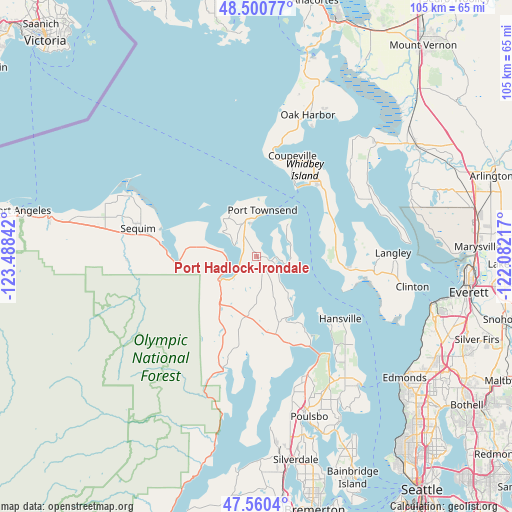
Port Hadlock-Irondale GPS coordinates[2]
48° 1' 57.828" North, 122° 47' 7.044" West
| Map corner | latitude | longitude |
|---|---|---|
| Upper-left | 48.50077°, | -123.48842° |
| Center: | 48.03273°, | -122.78529° |
| Lower-right: | 47.5604°, | -122.08217° |
| Map W x H: | 104.6×104.6 km | = 65×65mi |
| max Lat: | 71.29058° ⇑1.4% North |
| Port Hadlock-Irondale: | 48.03273° |
| min Lat: | ⇓98.6% South 19.06759° |
| min Long | Port Hadlock-Ir | max Long |
| -171.73463° | -122.78529° | -66.98998° |
| W 2.6%⇐ | ⇒97.4% E |
Elevation
Elevation of Port Hadlock-Irondale is 39 m = 128 ft, and this is 255.8 m = 839 ft below average elevation for this country.
| Max E: |
3189 m = 10463 ft | 81.8% |
| Avg. | 294.8 m = 967 ft | |
| Port Hadlock-Irondale | 39 m = 128 ft | |
Min E: |
-60 m = -197 ft | 18.2% |
See also: United States elevation on elevation.city.
Geographical zone
Port Hadlock-Irondale is located in North temperate zone (between Tropic of Cancer and the Arctic Circle). Distance of this North polar circle is 2060.4 km =1280.3 mi to North.| Distance of | km | miles | from Port Hadlock-Irondale |
|---|---|---|---|
| North Pole | 4666.3 | 2899.5 | to North |
| Arctic Circle | 2060.4 | 1280.3 | to North |
| Tropic Cancer | 2734.8 | 1699.3 | to South |
| Equator | 5340.7 | 3318.6 | to South |


Nearby cities:
15 places around Port Hadlock-Irondale: (largest is in red/bold)
• Bell Hill
22.4 km =13.9 mi,  276°
276°
• Camano
24.7 km =15.3 mi,  50°
50°
• Carlsborg
29.5 km =18.3 mi, 282°
• Clinton
32.5 km =20.2 mi,  100°
100°
• Coupeville
22.1 km =13.7 mi,  19°
19°
• Freeland
19.5 km =12.1 mi, 97°
• Hansville
21.4 km =13.3 mi,  126°
126°
• Langley
28.2 km =17.5 mi,  88°
88°
• Lofall
26.3 km =16.3 mi,  158°
158°
• Marrowstone
7.5 km =4.7 mi,  72°
72°
• Oak Harbor
30.8 km =19.1 mi, 19°
• Port Ludlow
14.1 km =8.8 mi,  147°
147°
• Port Townsend
9.6 km =6 mi,  11°
11°
• Quilcene
24.3 km =15.1 mi,  196°
196°
• Sequim
24.1 km =15 mi, 282°
Sources, notices
• [Note1] Compared only with cities in United States existing in our database
• [Src1] Map data: © OpenStreetMap contributors (CC-BY-SA)
• [Src2] Other city data from geonames.org with taken over terms of usage.
• [Src3] Geographical zone / Annual Mean Temperature by Robert A. Rohde @ Wikipedia
