Quincy geodata
Quincy (Washington) is a populated place; located in United States in America/Los_Angeles (GMT-7) time zone. With population of 7,365 people, there are 5616 cities with bigger population in this country. Compared to other cities in United States, 97% of cities are located further ↓South; 92.7% of cities are located further →East and 83.3% of cities have lower elevation than Quincy. Note1


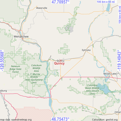
Quincy GPS coordinates[2]
47° 14' 3.48" North, 119° 51' 9.18" West
| Map corner | latitude | longitude |
|---|---|---|
| Upper-left | 47.70957°, | -120.55568° |
| Center: | 47.2343°, | -119.85255° |
| Lower-right: | 46.75473°, | -119.14943° |
| Map W x H: | 106.2×106.2 km | = 66×66mi |
| max Lat: | 71.29058° ⇑3% North |
| Quincy: | 47.2343° |
| min Lat: | ⇓97% South 19.06759° |
| min Long | Quincy | max Long |
| -171.73463° | -119.85255° | -66.98998° |
| W 7.3%⇐ | ⇒92.7% E |
Elevation
Elevation of Quincy is 395 m = 1296 ft, and this is 100.2 m = 329 ft above average elevation for this country.
| Max E: |
3189 m = 10463 ft | 16.7% |
| Quincy | 395 m 1296 ft | |
| Avg. | 294.8 m = 967 ft | |
Min E: |
-60 m = -197 ft | 83.3% |
See also: United States elevation on elevation.city.
Geographical zone
Quincy is located in North temperate zone (between Tropic of Cancer and the Arctic Circle). Distance of this North polar circle is 2149.2 km =1335.5 mi to North.| Distance of | km | miles | from Quincy |
|---|---|---|---|
| North Pole | 4755.1 | 2954.7 | to North |
| Arctic Circle | 2149.2 | 1335.5 | to North |
| Tropic Cancer | 2646 | 1644.1 | to South |
| Equator | 5252 | 3263.4 | to South |


Nearby cities:
15 places around Quincy: (largest is in red/bold)
• Cascade Valley
41.2 km =25.6 mi,  105°
105°
• East Wenatchee
38.9 km =24.2 mi,  301°
301°
• East Wenatchee Bench
38.7 km =24 mi, 303°
• Ephrata
24.4 km =15.2 mi,  67°
67°
• George
17.3 km =10.7 mi,  180°
180°
• Lakeview
30.6 km =19 mi,  59°
59°
• Moses Lake
44.9 km =27.9 mi,  104°
104°
• Moses Lake North
40.7 km =25.3 mi, 96°
• Rock Island
27.1 km =16.8 mi,  305°
305°
• Royal City
40.7 km =25.3 mi,  155°
155°
• Soap Lake
32.3 km =20.1 mi, 57°
• South Wenatchee
37.2 km =23.1 mi, 297°
• Sunnyslope
45.1 km =28 mi, 306°
• Wenatchee
40.4 km =25.1 mi, 301°
• West Wenatchee
44.3 km =27.5 mi, 301°
Sources, notices
• [Note1] Compared only with cities in United States existing in our database
• [Src1] Map data: © OpenStreetMap contributors (CC-BY-SA)
• [Src2] Other city data from geonames.org with taken over terms of usage.
• [Src3] Geographical zone / Annual Mean Temperature by Robert A. Rohde @ Wikipedia
