George geodata
George (Washington) is a populated place; located in United States in America/Los_Angeles (GMT-7) time zone. With population of 501 people, there are 20887 cities with bigger population in this country. Compared to other cities in United States, 96.7% of cities are located further ↓South; 92.7% of cities are located further →East and 81.7% of cities have lower elevation than George. Note1


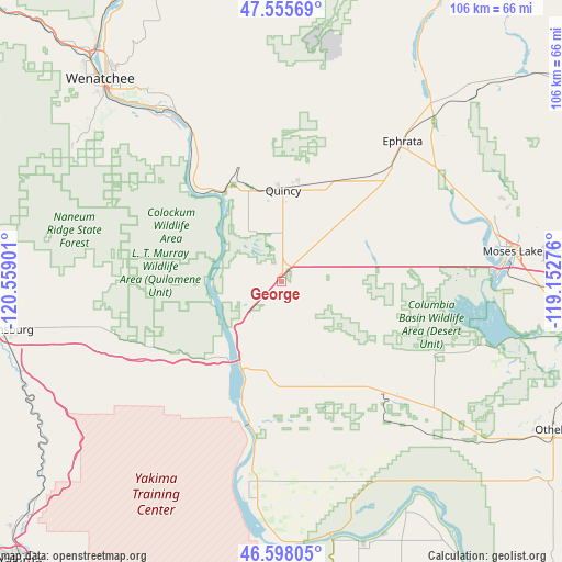
George GPS coordinates[2]
47° 4' 44.472" North, 119° 51' 21.168" West
| Map corner | latitude | longitude |
|---|---|---|
| Upper-left | 47.55569°, | -120.55901° |
| Center: | 47.07902°, | -119.85588° |
| Lower-right: | 46.59805°, | -119.15276° |
| Map W x H: | 106.5×106.5 km | = 66.2×66.2mi |
| max Lat: | 71.29058° ⇑3.3% North |
| George: | 47.07902° |
| min Lat: | ⇓96.7% South 19.06759° |
| min Long | George | max Long |
| -171.73463° | -119.85588° | -66.98998° |
| W 7.3%⇐ | ⇒92.7% E |
Elevation
Elevation of George is 373 m = 1224 ft, and this is 78.2 m = 257 ft above average elevation for this country.
| Max E: |
3189 m = 10463 ft | 18.3% |
| George | 373 m 1224 ft | |
| Avg. | 294.8 m = 967 ft | |
Min E: |
-60 m = -197 ft | 81.7% |
See also: United States elevation on elevation.city.
Geographical zone
George is located in North temperate zone (between Tropic of Cancer and the Arctic Circle). Distance of this North polar circle is 2166.5 km =1346.2 mi to North.| Distance of | km | miles | from George |
|---|---|---|---|
| North Pole | 4772.4 | 2965.4 | to North |
| Arctic Circle | 2166.5 | 1346.2 | to North |
| Tropic Cancer | 2628.8 | 1633.5 | to South |
| Equator | 5234.7 | 3252.7 | to South |


Nearby cities:
15 places around George: (largest is in red/bold)
• Cascade Valley
40.4 km =25.1 mi,  81°
81°
• Desert Aire
44.7 km =27.8 mi,  185°
185°
• East Wenatchee
49.9 km =31 mi,  318°
318°
• East Wenatchee Bench
50.2 km =31.2 mi, 320°
• Ephrata
35 km =21.7 mi,  40°
40°
• Kittitas
43.8 km =27.2 mi,  255°
255°
• Lakeview
42.3 km =26.3 mi, 39°
• Mattawa
38.1 km =23.7 mi, 185°
• Moses Lake
44.1 km =27.4 mi, 82°
• Moses Lake North
42.7 km =26.5 mi,  72°
72°
• Quincy
17.3 km =10.7 mi,  0°
0°
• Rock Island
39.6 km =24.6 mi,  326°
326°
• Royal City
26.2 km =16.3 mi,  139°
139°
• Soap Lake
44.2 km =27.5 mi, 38°
• South Wenatchee
47.6 km =29.6 mi, 316°
Sources, notices
• [Note1] Compared only with cities in United States existing in our database
• [Src1] Map data: © OpenStreetMap contributors (CC-BY-SA)
• [Src2] Other city data from geonames.org with taken over terms of usage.
• [Src3] Geographical zone / Annual Mean Temperature by Robert A. Rohde @ Wikipedia
