East Wenatchee geodata
East Wenatchee (Washington) is a populated place; located in United States in America/Los_Angeles (GMT-7) time zone. With population of 13,659 people, there are 3518 cities with bigger population in this country. Compared to other cities in United States, 97.4% of cities are located further ↓South; 93.1% of cities are located further →East and 51.9% of cities have lower elevation than East Wenatchee. Note1


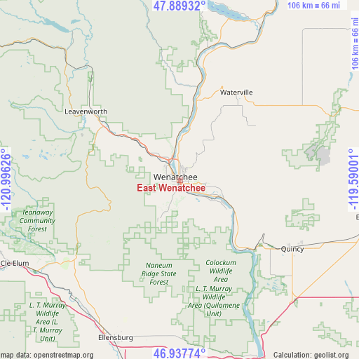
East Wenatchee GPS coordinates[2]
47° 24' 56.448" North, 120° 17' 35.268" West
| Map corner | latitude | longitude |
|---|---|---|
| Upper-left | 47.88932°, | -120.99626° |
| Center: | 47.41568°, | -120.29313° |
| Lower-right: | 46.93774°, | -119.59001° |
| Map W x H: | 105.8×105.8 km | = 65.7×65.7mi |
| max Lat: | 71.29058° ⇑2.6% North |
| East Wenatchee: | 47.41568° |
| min Lat: | ⇓97.4% South 19.06759° |
| min Long | East Wenatchee | max Long |
| -171.73463° | -120.29313° | -66.98998° |
| W 6.9%⇐ | ⇒93.1% E |
Elevation
Elevation of East Wenatchee is 206 m = 676 ft, and this is 88.8 m = 291 ft below average elevation for this country.
| Max E: |
3189 m = 10463 ft | 48.1% |
| Avg. | 294.8 m = 967 ft | |
| East Wenatchee | 206 m = 676 ft | |
Min E: |
-60 m = -197 ft | 51.9% |
See also: United States elevation on elevation.city.
Geographical zone
East Wenatchee is located in North temperate zone (between Tropic of Cancer and the Arctic Circle). Distance of this North polar circle is 2129 km =1322.9 mi to North.| Distance of | km | miles | from East Wenatchee |
|---|---|---|---|
| North Pole | 4734.9 | 2942.1 | to North |
| Arctic Circle | 2129 | 1322.9 | to North |
| Tropic Cancer | 2666.2 | 1656.7 | to South |
| Equator | 5272.1 | 3275.9 | to South |


Nearby cities:
15 places around East Wenatchee: (largest is in red/bold)
• Cashmere
17.8 km =11.1 mi,  311°
311°
• Chelan
51.6 km =32.1 mi,  23°
23°
• East Wenatchee Bench
1.4 km =0.9 mi,  38°
38°
• Ellensburg
50.4 km =31.3 mi,  202°
202°
• Entiat
29.6 km =18.4 mi,  12°
12°
• George
49.9 km =31 mi,  138°
138°
• Kittitas
49 km =30.4 mi,  191°
191°
• Leavenworth
34.2 km =21.3 mi, 305°
• Quincy
38.9 km =24.2 mi,  121°
121°
• Rock Island
12 km =7.5 mi,  110°
110°
• South Wenatchee
2.9 km =1.8 mi,  174°
174°
• Sunnyslope
7.2 km =4.5 mi,  332°
332°
• Waterville
30.7 km =19.1 mi,  32°
32°
• Wenatchee
1.6 km =1 mi,  303°
303°
• West Wenatchee
5.5 km =3.4 mi, 304°
Sources, notices
• [Note1] Compared only with cities in United States existing in our database
• [Src1] Map data: © OpenStreetMap contributors (CC-BY-SA)
• [Src2] Other city data from geonames.org with taken over terms of usage.
• [Src3] Geographical zone / Annual Mean Temperature by Robert A. Rohde @ Wikipedia
