Startup geodata
Startup (Washington) is a populated place; located in United States in America/Los_Angeles (GMT-7) time zone. With population of 676 people, there are 18907 cities with bigger population in this country. Compared to other cities in United States, 98.4% of cities are located further ↓South; 94.6% of cities are located further →East and 80.6% of cities have higher elevation than Startup. Note1


Startup GPS coordinates[2]
47° 52' 4.368" North, 121° 44' 25.44" West
| Map corner | latitude | longitude |
|---|---|---|
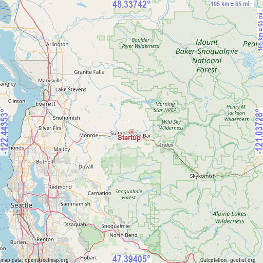
| Upper-left | 48.33742°, | -122.44353° |
| Center: | 47.86788°, | -121.7404° |
| Lower-right: | 47.39405°, | -121.03728° |
| Map W x H: | 104.9×104.9 km | = 65.2×65.2mi |
| max Lat: | 71.29058° ⇑1.6% North |
| Startup: | 47.86788° |
| min Lat: | ⇓98.4% South 19.06759° |
| min Long | Startup | max Long |
| -171.73463° | -121.7404° | -66.98998° |
| W 5.4%⇐ | ⇒94.6% E |
Elevation
Elevation of Startup is 44 m = 144 ft, and this is 250.8 m = 823 ft below average elevation for this country.
| Max E: |
3189 m = 10463 ft | 80.6% |
| Avg. | 294.8 m = 967 ft | |
| Startup | 44 m = 144 ft | |
Min E: |
-60 m = -197 ft | 19.4% |
See also: United States elevation on elevation.city.
Geographical zone
Startup is located in North temperate zone (between Tropic of Cancer and the Arctic Circle). Distance of this North polar circle is 2078.8 km =1291.7 mi to North.| Distance of | km | miles | from Startup |
|---|---|---|---|
| North Pole | 4684.7 | 2910.9 | to North |
| Arctic Circle | 2078.8 | 1291.7 | to North |
| Tropic Cancer | 2716.5 | 1688 | to South |
| Equator | 5322.4 | 3307.2 | to South |


Nearby cities:
15 places around Startup: (largest is in red/bold)
• Cathcart
26.9 km =16.7 mi,  265°
265°
• Duvall
23 km =14.3 mi,  232°
232°
• Echo Lake
24.7 km =15.3 mi,  247°
247°
• Gold Bar
3.5 km =2.2 mi,  110°
110°
• Lake Bosworth
26 km =16.2 mi,  319°
319°
• Lake Marcel-Stillwater
23.5 km =14.6 mi,  213°
213°
• Lake Roesiger
19.1 km =11.9 mi,  312°
312°
• Machias
26 km =16.2 mi,  299°
299°
• May Creek
5.7 km =3.5 mi, 105°
• Monroe
17.3 km =10.7 mi, 265°
• Monroe North
18.5 km =11.5 mi, 274°
• Snohomish
27.1 km =16.8 mi,  280°
280°
• Sultan
5.7 km =3.5 mi,  264°
264°
• Three Lakes
21.9 km =13.6 mi,  292°
292°
• Woods Creek
11.8 km =7.3 mi, 275°
Sources, notices
• [Note1] Compared only with cities in United States existing in our database
• [Src1] Map data: © OpenStreetMap contributors (CC-BY-SA)
• [Src2] Other city data from geonames.org with taken over terms of usage.
• [Src3] Geographical zone / Annual Mean Temperature by Robert A. Rohde @ Wikipedia
