Lake Marcel-Stillwater geodata
Lake Marcel-Stillwater (Washington) is a populated place; located in United States in America/Los_Angeles (GMT-7) time zone. With population of 1,277 people, there are 14696 cities with bigger population in this country. Compared to other cities in United States, 98.1% of cities are located further ↓South; 94.9% of cities are located further →East and 70% of cities have higher elevation than Lake Marcel-Stillwater. Note1


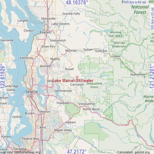
Lake Marcel-Stillwater GPS coordinates[2]
47° 41' 33.468" North, 121° 54' 54.468" West
| Map corner | latitude | longitude |
|---|---|---|
| Upper-left | 48.16376°, | -122.61826° |
| Center: | 47.69263°, | -121.91513° |
| Lower-right: | 47.2172°, | -121.21201° |
| Map W x H: | 105.2×105.2 km | = 65.4×65.4mi |
| max Lat: | 71.29058° ⇑1.9% North |
| Lake Marcel-Stillwater: | 47.69263° |
| min Lat: | ⇓98.1% South 19.06759° |
| min Long | Lake Marcel-Sti | max Long |
| -171.73463° | -121.91513° | -66.98998° |
| W 5.1%⇐ | ⇒94.9% E |
Elevation
Elevation of Lake Marcel-Stillwater is 101 m = 331 ft, and this is 193.8 m = 636 ft below average elevation for this country.
| Max E: |
3189 m = 10463 ft | 70% |
| Avg. | 294.8 m = 967 ft | |
| Lake Marcel-Stillwater | 101 m = 331 ft | |
Min E: |
-60 m = -197 ft | 30% |
See also: United States elevation on elevation.city.
Geographical zone
Lake Marcel-Stillwater is located in North temperate zone (between Tropic of Cancer and the Arctic Circle). Distance of this North polar circle is 2098.3 km =1303.8 mi to North.| Distance of | km | miles | from Lake Marcel-Stillwater |
|---|---|---|---|
| North Pole | 4704.1 | 2923 | to North |
| Arctic Circle | 2098.3 | 1303.8 | to North |
| Tropic Cancer | 2697 | 1675.8 | to South |
| Equator | 5302.9 | 3295.1 | to South |


Nearby cities:
15 places around Lake Marcel-Stillwater: (largest is in red/bold)
• Ames Lake
7.7 km =4.8 mi,  209°
209°
• Carnation
5 km =3.1 mi,  179°
179°
• City of Sammamish
13.4 km =8.3 mi,  223°
223°
• Cottage Lake
13.4 km =8.3 mi,  295°
295°
• Duvall
7.6 km =4.7 mi,  316°
316°
• Echo Lake
14.2 km =8.8 mi, 315°
• Fall City
14.1 km =8.8 mi,  171°
171°
• Klahanie
15.2 km =9.4 mi, 207°
• Maltby
19.4 km =12.1 mi,  310°
310°
• Monroe
18.6 km =11.6 mi,  347°
347°
• Redmond
15.6 km =9.7 mi,  262°
262°
• Sammamish
13.6 km =8.5 mi,  245°
245°
• Snoqualmie
19.4 km =12.1 mi,  159°
159°
• Union Hill-Novelty Hill
8.6 km =5.3 mi, 259°
• West Lake Sammamish
18.9 km =11.7 mi,  227°
227°
Sources, notices
• [Note1] Compared only with cities in United States existing in our database
• [Src1] Map data: © OpenStreetMap contributors (CC-BY-SA)
• [Src2] Other city data from geonames.org with taken over terms of usage.
• [Src3] Geographical zone / Annual Mean Temperature by Robert A. Rohde @ Wikipedia
