Vancouver geodata
Vancouver (Washington) is a seat of a second-order administrative division; located in United States in America/Los_Angeles (GMT-7) time zone. With population of 172,860 people, there are 160 cities with bigger population in this country. Compared to other cities in United States, 94.4% of cities are located further ↓South; 97.1% of cities are located further →East and 77.7% of cities have higher elevation than Vancouver. Note1


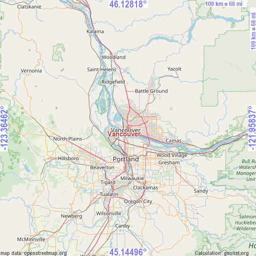
Vancouver GPS coordinates[2]
45° 38' 19.428" North, 122° 39' 41.364" West
| Map corner | latitude | longitude |
|---|---|---|
| Upper-left | 46.12818°, | -123.36462° |
| Center: | 45.63873°, | -122.66149° |
| Lower-right: | 45.14496°, | -121.95837° |
| Map W x H: | 109.3×109.3 km | = 67.9×67.9mi |
| max Lat: | 71.29058° ⇑5.6% North |
| Vancouver: | 45.63873° |
| min Lat: | ⇓94.4% South 19.06759° |
| min Long | Vancouver | max Long |
| -171.73463° | -122.66149° | -66.98998° |
| W 2.9%⇐ | ⇒97.1% E |
Elevation
Elevation of Vancouver is 57 m = 187 ft, and this is 237.8 m = 780 ft below average elevation for this country.
| Max E: |
3189 m = 10463 ft | 77.7% |
| Avg. | 294.8 m = 967 ft | |
| Vancouver | 57 m = 187 ft | |
Min E: |
-60 m = -197 ft | 22.3% |
See also: Vancouver elevation on elevation.city.
Geographical zone
Vancouver is located in North temperate zone (between Tropic of Cancer and the Arctic Circle). Distance of this North polar circle is 2326.6 km =1445.7 mi to North.| Distance of | km | miles | from Vancouver |
|---|---|---|---|
| North Pole | 4932.5 | 3064.9 | to North |
| Arctic Circle | 2326.6 | 1445.7 | to North |
| Tropic Cancer | 2468.6 | 1533.9 | to South |
| Equator | 5074.6 | 3153.2 | to South |


Nearby cities:
15 places around Vancouver: (largest is in red/bold)
• Barberton
7.8 km =4.8 mi,  38°
38°
• Bridgeton
4.2 km =2.6 mi,  188°
188°
• Felida
8.6 km =5.3 mi,  335°
335°
• Five Corners
8.4 km =5.2 mi,  52°
52°
• Hazel Dell
3.6 km =2.2 mi,  358°
358°
• Kenton
6.5 km =4 mi, 193°
• Lake Shore
6.2 km =3.9 mi, 338°
• Maywood Park
12.4 km =7.7 mi,  140°
140°
• Minnehaha
2.5 km =1.6 mi,  23°
23°
• Mount Vista
10.9 km =6.8 mi,  11°
11°
• North Portland
4.5 km =2.8 mi,  225°
225°
• Orchards
8.4 km =5.2 mi,  68°
68°
• Portland
12.9 km =8 mi, 185°
• Salmon Creek
8.1 km =5 mi, 6°
• Walnut Grove
5.8 km =3.6 mi,  56°
56°
Sources, notices
• [Note1] Compared only with cities in United States existing in our database
• [Src1] Map data: © OpenStreetMap contributors (CC-BY-SA)
• [Src2] Other city data from geonames.org with taken over terms of usage.
• [Src3] Geographical zone / Annual Mean Temperature by Robert A. Rohde @ Wikipedia
