Washougal geodata
Washougal (Washington) is a populated place; located in United States in America/Los_Angeles (GMT-7) time zone. With population of 15,288 people, there are 3189 cities with bigger population in this country. Compared to other cities in United States, 94.2% of cities are located further ↓South; 96.2% of cities are located further →East and 86.2% of cities have higher elevation than Washougal. Note1


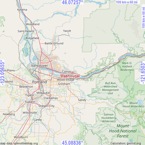
Washougal GPS coordinates[2]
45° 34' 57.432" North, 122° 21' 12.312" West
| Map corner | latitude | longitude |
|---|---|---|
| Upper-left | 46.07257°, | -123.05655° |
| Center: | 45.58262°, | -122.35342° |
| Lower-right: | 45.08836°, | -121.6503° |
| Map W x H: | 109.4×109.4 km | = 68×68mi |
| max Lat: | 71.29058° ⇑5.8% North |
| Washougal: | 45.58262° |
| min Lat: | ⇓94.2% South 19.06759° |
| min Long | Washougal | max Long |
| -171.73463° | -122.35342° | -66.98998° |
| W 3.8%⇐ | ⇒96.2% E |
Elevation
Elevation of Washougal is 25 m = 82 ft, and this is 269.8 m = 885 ft below average elevation for this country.
| Max E: |
3189 m = 10463 ft | 86.2% |
| Avg. | 294.8 m = 967 ft | |
| Washougal | 25 m = 82 ft | |
Min E: |
-60 m = -197 ft | 13.8% |
See also: United States elevation on elevation.city.
Geographical zone
Washougal is located in North temperate zone (between Tropic of Cancer and the Arctic Circle). Distance of this North polar circle is 2332.9 km =1449.6 mi to North.| Distance of | km | miles | from Washougal |
|---|---|---|---|
| North Pole | 4938.7 | 3068.8 | to North |
| Arctic Circle | 2332.9 | 1449.6 | to North |
| Tropic Cancer | 2462.4 | 1530.1 | to South |
| Equator | 5068.3 | 3149.3 | to South |


Nearby cities:
15 places around Washougal: (largest is in red/bold)
• Camas
3.6 km =2.2 mi,  277°
277°
• Damascus
20.1 km =12.5 mi,  204°
204°
• Fairview
8 km =5 mi,  231°
231°
• Fern Prairie
7 km =4.3 mi,  329°
329°
• Five Corners
20.6 km =12.8 mi,  303°
303°
• Gresham
11.2 km =7 mi,  212°
212°
• Happy Valley
20.4 km =12.7 mi,  222°
222°
• Hockinson
20.1 km =12.5 mi, 328°
• Lents
20.2 km =12.6 mi,  235°
235°
• Maywood Park
16.4 km =10.2 mi,  258°
258°
• Mill Plain
12.8 km =8 mi, 301°
• Orchards
18.6 km =11.6 mi, 300°
• Troutdale
5.5 km =3.4 mi, 208°
• Walnut Grove
21.3 km =13.2 mi, 296°
• Wood Village
7.4 km =4.6 mi, 223°
Sources, notices
• [Note1] Compared only with cities in United States existing in our database
• [Src1] Map data: © OpenStreetMap contributors (CC-BY-SA)
• [Src2] Other city data from geonames.org with taken over terms of usage.
• [Src3] Geographical zone / Annual Mean Temperature by Robert A. Rohde @ Wikipedia
