Waterville geodata
Waterville (Washington) is a seat of a second-order administrative division; located in United States in America/Los_Angeles (GMT-7) time zone. With population of 1,171 people, there are 15282 cities with bigger population in this country. Compared to other cities in United States, 98% of cities are located further ↓South; 92.9% of cities are located further →East and 92% of cities have lower elevation than Waterville. Note1


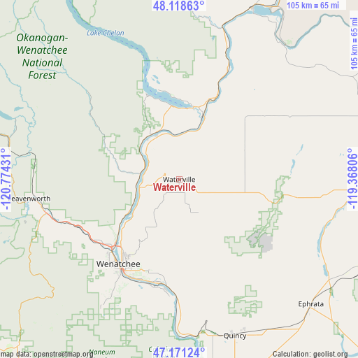
Waterville GPS coordinates[2]
47° 38' 49.488" North, 120° 4' 16.248" West
| Map corner | latitude | longitude |
|---|---|---|
| Upper-left | 48.11863°, | -120.77431° |
| Center: | 47.64708°, | -120.07118° |
| Lower-right: | 47.17124°, | -119.36806° |
| Map W x H: | 105.3×105.3 km | = 65.4×65.4mi |
| max Lat: | 71.29058° ⇑2% North |
| Waterville: | 47.64708° |
| min Lat: | ⇓98% South 19.06759° |
| min Long | Waterville | max Long |
| -171.73463° | -120.07118° | -66.98998° |
| W 7.1%⇐ | ⇒92.9% E |
Elevation
Elevation of Waterville is 798 m = 2618 ft, and this is 503.2 m = 1651 ft above average elevation for this country.
| Max E: |
3189 m = 10463 ft | 8% |
| Waterville | 798 m 2618 ft | |
| Avg. | 294.8 m = 967 ft | |
Min E: |
-60 m = -197 ft | 92% |
See also: United States elevation on elevation.city.
Geographical zone
Waterville is located in North temperate zone (between Tropic of Cancer and the Arctic Circle). Distance of this North polar circle is 2103.3 km =1306.9 mi to North.| Distance of | km | miles | from Waterville |
|---|---|---|---|
| North Pole | 4709.2 | 2926.2 | to North |
| Arctic Circle | 2103.3 | 1306.9 | to North |
| Tropic Cancer | 2691.9 | 1672.7 | to South |
| Equator | 5297.9 | 3292 | to South |


Nearby cities:
15 places around Waterville: (largest is in red/bold)
• Cashmere
33 km =20.5 mi,  245°
245°
• Chelan
21.9 km =13.6 mi,  10°
10°
• East Wenatchee
30.7 km =19.1 mi,  212°
212°
• East Wenatchee Bench
29.2 km =18.1 mi, 212°
• Entiat
10.8 km =6.7 mi,  287°
287°
• Granite Falls
29 km =18 mi,  338°
338°
• Leavenworth
44.6 km =27.7 mi,  262°
262°
• Manson
27.2 km =16.9 mi,  346°
346°
• Pateros
46.6 km =29 mi,  15°
15°
• Quincy
48.8 km =30.3 mi,  160°
160°
• Rock Island
30.5 km =19 mi,  190°
190°
• South Wenatchee
32.9 km =20.4 mi, 209°
• Sunnyslope
27.8 km =17.3 mi,  225°
225°
• Wenatchee
30.7 km =19.1 mi,  215°
215°
• West Wenatchee
31 km =19.3 mi, 223°
Sources, notices
• [Note1] Compared only with cities in United States existing in our database
• [Src1] Map data: © OpenStreetMap contributors (CC-BY-SA)
• [Src2] Other city data from geonames.org with taken over terms of usage.
• [Src3] Geographical zone / Annual Mean Temperature by Robert A. Rohde @ Wikipedia
