Newcastle geodata
Newcastle (Wyoming) is a seat of a second-order administrative division; located in United States in America/Denver (GMT-6) time zone. With population of 3,534 people, there are 8823 cities with bigger population in this country. Compared to other cities in United States, 87.8% of cities are located further ↓South; 82.7% of cities are located further →East and 95.4% of cities have lower elevation than Newcastle. Note1


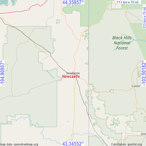
Newcastle GPS coordinates[2]
43° 51' 16.92" North, 104° 12' 17.784" West
| Map corner | latitude | longitude |
|---|---|---|
| Upper-left | 44.35957°, | -104.90807° |
| Center: | 43.8547°, | -104.20494° |
| Lower-right: | 43.34552°, | -103.50182° |
| Map W x H: | 112.8×112.7 km | = 70.1×70mi |
| max Lat: | 71.29058° ⇑12.2% North |
| Newcastle: | 43.8547° |
| min Lat: | ⇓87.8% South 19.06759° |
| min Long | Newcastle | max Long |
| -171.73463° | -104.20494° | -66.98998° |
| W 17.3%⇐ | ⇒82.7% E |
Elevation
Elevation of Newcastle is 1323 m = 4341 ft, and this is 1028.2 m = 3373 ft above average elevation for this country.
| Max E: |
3189 m = 10463 ft | 4.6% |
| Newcastle | 1323 m 4341 ft | |
| Avg. | 294.8 m = 967 ft | |
Min E: |
-60 m = -197 ft | 95.4% |
See also: United States elevation on elevation.city.
Geographical zone
Newcastle is located in North temperate zone (between Tropic of Cancer and the Arctic Circle). Distance of this Northern Tropic circle is 2270.3 km =1410.7 mi to South.| Distance of | km | miles | from Newcastle |
|---|---|---|---|
| North Pole | 5130.9 | 3188.2 | to North |
| Arctic Circle | 2525 | 1569 | to North |
| Tropic Cancer | 2270.3 | 1410.7 | to South |
| Equator | 4876.2 | 3029.9 | to South |


Nearby cities:
15 places around Newcastle: (largest is in red/bold)
• Colonial Pine Hills
73.2 km =45.5 mi,  76°
76°
• Custer
49.6 km =30.8 mi,  101°
101°
• Deadwood
69.3 km =43.1 mi,  33°
33°
• Edgemont
68.7 km =42.7 mi,  153°
153°
• Hill City
51.2 km =31.8 mi, 80°
• Hot Springs
75.3 km =46.8 mi,  128°
128°
• Johnson Siding
66.5 km =41.3 mi,  67°
67°
• Lead
65.5 km =40.7 mi, 32°
• Moorcroft
74.9 km =46.5 mi,  307°
307°
• North Spearfish
76.7 km =47.7 mi,  18°
18°
• Piedmont
77.5 km =48.2 mi,  57°
57°
• Pine Haven
73.9 km =45.9 mi,  319°
319°
• Spearfish
75.9 km =47.2 mi, 21°
• Sundance
62.8 km =39 mi,  347°
347°
• Upton
43.5 km =27 mi, 308°
Sources, notices
• [Note1] Compared only with cities in United States existing in our database
• [Src1] Map data: © OpenStreetMap contributors (CC-BY-SA)
• [Src2] Other city data from geonames.org with taken over terms of usage.
• [Src3] Geographical zone / Annual Mean Temperature by Robert A. Rohde @ Wikipedia
