Fort Yukon geodata
Fort Yukon (Alaska) is a populated place; located in United States in America/Anchorage (GMT-8) time zone. With population of 570 people, there are 20030 cities with bigger population in this country. Compared to other cities in United States, 100% of cities are located further ↓South; 98.9% of cities are located further →East and 65% of cities have higher elevation than Fort Yukon. Note1


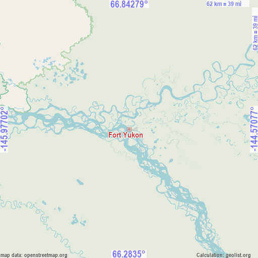
Fort Yukon GPS coordinates[2]
66° 33' 52.992" North, 145° 16' 26.004" West
| Map corner | latitude | longitude |
|---|---|---|
| Upper-left | 66.84279°, | -145.97702° |
| Center: | 66.56472°, | -145.27389° |
| Lower-right: | 66.2835°, | -144.57077° |
| Map W x H: | 62.2×62.2 km | = 38.6×38.6mi |
| max Lat: | 71.29058° ⇑0% North |
| Fort Yukon: | 66.56472° |
| min Lat: | ⇓100% South 19.06759° |
| min Long | Fort Yukon | max Long |
| -171.73463° | -145.27389° | -66.98998° |
| W 1.1%⇐ | ⇒98.9% E |
Elevation
Elevation of Fort Yukon is 128 m = 420 ft, and this is 166.8 m = 547 ft below average elevation for this country.
| Max E: |
3189 m = 10463 ft | 65% |
| Avg. | 294.8 m = 967 ft | |
| Fort Yukon | 128 m = 420 ft | |
Min E: |
-60 m = -197 ft | 35% |
See also: United States elevation on elevation.city.
Geographical zone
Fort Yukon is located in North Frigid zone (between North Pole and Arctic Circle). Distance of this North polar circle is 0.1 km =0.1 mi to South.| Distance of | km | miles | from Fort Yukon |
|---|---|---|---|
| North Pole | 2605.8 | 1619.2 | to North |
| Arctic Circle | 0.1 | 0.1 | to South |
| Tropic Cancer | 4795.4 | 2979.7 | to South |
| Equator | 7401.3 | 4599 | to South |


Nearby cities:
15 places around Fort Yukon: (largest is in red/bold)
• Badger
221.8 km =137.8 mi,  207°
207°
• Big Delta
269.5 km =167.5 mi,  185°
185°
• College
222.3 km =138.1 mi, 211°
• Delta Junction
281.8 km =175.1 mi,  184°
184°
• Eielson Air Force Base
226.7 km =140.9 mi,  201°
201°
• Ester
228.4 km =141.9 mi, 213°
• Fairbanks
222.1 km =138 mi, 210°
• Farmers Loop
214.9 km =133.5 mi, 211°
• Fort Greely
292 km =181.4 mi, 182°
• Moose Creek
223.3 km =138.8 mi, 202°
• North Pole
222.9 km =138.5 mi, 205°
• Pleasant Valley
200.8 km =124.8 mi, 201°
• Salcha
238.9 km =148.4 mi, 198°
• South Van Horn
226.5 km =140.7 mi, 210°
• Two Rivers
204.7 km =127.2 mi, 203°
Sources, notices
• [Note1] Compared only with cities in United States existing in our database
• [Src1] Map data: © OpenStreetMap contributors (CC-BY-SA)
• [Src2] Other city data from geonames.org with taken over terms of usage.
• [Src3] Geographical zone / Annual Mean Temperature by Robert A. Rohde @ Wikipedia
