Andrews AFB geodata
Andrews AFB (Maryland) is a populated place; located in United States in America/New_York (GMT-4) time zone. With population of 2,973 people, there are 9677 cities with bigger population in this country. Compared to other cities in United States, 56.5% of cities are located further ↑North; 81.1% of cities are located further ←West and 73.3% of cities have higher elevation than Andrews AFB. Note1


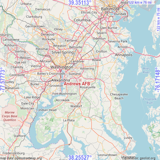
Andrews AFB GPS coordinates[2]
38° 48' 19.116" North, 76° 52' 28.56" West
| Map corner | latitude | longitude |
|---|---|---|
| Upper-left | 39.35113°, | -77.57773° |
| Center: | 38.80531°, | -76.8746° |
| Lower-right: | 38.25527°, | -76.17148° |
| Map W x H: | 121.8×121.8 km | = 75.7×75.7mi |
| max Lat: | 71.29058° ⇑56.5% North |
| Andrews AFB: | 38.80531° |
| min Lat: | ⇓43.5% South 19.06759° |
| min Long | Andrews AFB | max Long |
| -171.73463° | -76.8746° | -66.98998° |
| W 81.1%⇐ | ⇒18.9% E |
Elevation
Elevation of Andrews AFB is 81 m = 266 ft, and this is 213.8 m = 701 ft below average elevation for this country.
| Max E: |
3189 m = 10463 ft | 73.3% |
| Avg. | 294.8 m = 967 ft | |
| Andrews AFB | 81 m = 266 ft | |
Min E: |
-60 m = -197 ft | 26.7% |
See also: United States elevation on elevation.city.
Geographical zone
Andrews AFB is located in North temperate zone (between Tropic of Cancer and the Arctic Circle). Distance of this Northern Tropic circle is 1708.8 km =1061.8 mi to South.| Distance of | km | miles | from Andrews AFB |
|---|---|---|---|
| North Pole | 5692.3 | 3537 | to North |
| Arctic Circle | 3086.4 | 1917.8 | to North |
| Tropic Cancer | 1708.8 | 1061.8 | to South |
| Equator | 4314.7 | 2681 | to South |


Nearby cities:
15 places around Andrews AFB: (largest is in red/bold)
• Camp Springs
2.8 km =1.7 mi,  266°
266°
• Clinton
4.9 km =3 mi,  204°
204°
• District Heights
6 km =3.7 mi,  347°
347°
• Forestville
4.4 km =2.7 mi,  359°
359°
• Marlow Heights
7.4 km =4.6 mi,  295°
295°
• Mellwood
4.4 km =2.7 mi,  82°
82°
• Morningside
3.1 km =1.9 mi,  332°
332°
• Queenland
7.2 km =4.5 mi,  90°
90°
• Rosaryville
7.8 km =4.8 mi,  133°
133°
• Silver Hill
7.4 km =4.6 mi, 303°
• Suitland
6.4 km =4 mi,  318°
318°
• Suitland-Silver Hill
6.4 km =4 mi, 316°
• Temple Hills
6.2 km =3.9 mi,  278°
278°
• Walker Mill
7.9 km =4.9 mi, 351°
• Westphalia
7.1 km =4.4 mi,  50°
50°
Sources, notices
• [Note1] Compared only with cities in United States existing in our database
• [Src1] Map data: © OpenStreetMap contributors (CC-BY-SA)
• [Src2] Other city data from geonames.org with taken over terms of usage.
• [Src3] Geographical zone / Annual Mean Temperature by Robert A. Rohde @ Wikipedia
