Rosaryville geodata
Rosaryville (Maryland) is a populated place; located in United States in America/New_York (GMT-4) time zone. With population of 10,697 people, there are 4270 cities with bigger population in this country. Compared to other cities in United States, 56.9% of cities are located further ↑North; 81.4% of cities are located further ←West and 75.8% of cities have higher elevation than Rosaryville. Note1


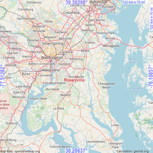
Rosaryville GPS coordinates[2]
38° 45' 24.408" North, 76° 48' 34.884" West
| Map corner | latitude | longitude |
|---|---|---|
| Upper-left | 39.30298°, | -77.51282° |
| Center: | 38.75678°, | -76.80969° |
| Lower-right: | 38.20637°, | -76.10657° |
| Map W x H: | 121.9×121.9 km | = 75.7×75.7mi |
| max Lat: | 71.29058° ⇑56.9% North |
| Rosaryville: | 38.75678° |
| min Lat: | ⇓43.1% South 19.06759° |
| min Long | Rosaryville | max Long |
| -171.73463° | -76.80969° | -66.98998° |
| W 81.4%⇐ | ⇒18.6% E |
Elevation
Elevation of Rosaryville is 67 m = 220 ft, and this is 227.8 m = 747 ft below average elevation for this country.
| Max E: |
3189 m = 10463 ft | 75.8% |
| Avg. | 294.8 m = 967 ft | |
| Rosaryville | 67 m = 220 ft | |
Min E: |
-60 m = -197 ft | 24.2% |
See also: United States elevation on elevation.city.
Geographical zone
Rosaryville is located in North temperate zone (between Tropic of Cancer and the Arctic Circle). Distance of this Northern Tropic circle is 1703.4 km =1058.4 mi to South.| Distance of | km | miles | from Rosaryville |
|---|---|---|---|
| North Pole | 5697.7 | 3540.4 | to North |
| Arctic Circle | 3091.8 | 1921.2 | to North |
| Tropic Cancer | 1703.4 | 1058.4 | to South |
| Equator | 4309.3 | 2677.7 | to South |


Nearby cities:
15 places around Rosaryville: (largest is in red/bold)
• Andrews AFB
7.8 km =4.8 mi,  313°
313°
• Brandywine
7.4 km =4.6 mi,  206°
206°
• Brock Hall
11.2 km =7 mi,  22°
22°
• Camp Springs
9.9 km =6.2 mi,  301°
301°
• Cedarville
10.5 km =6.5 mi,  176°
176°
• Clinton
7.7 km =4.8 mi,  276°
276°
• Croom
4 km =2.5 mi,  96°
96°
• Greater Upper Marlboro
9.9 km =6.2 mi,  32°
32°
• Marlboro Village
8.9 km =5.5 mi, 22°
• Marlton
2.5 km =1.6 mi,  42°
42°
• Mellwood
6.1 km =3.8 mi,  348°
348°
• Morningside
10.8 km =6.7 mi,  319°
319°
• Queenland
5.6 km =3.5 mi, 16°
• Upper Marlboro
8.4 km =5.2 mi, 38°
• Westphalia
9.9 km =6.2 mi,  359°
359°
Sources, notices
• [Note1] Compared only with cities in United States existing in our database
• [Src1] Map data: © OpenStreetMap contributors (CC-BY-SA)
• [Src2] Other city data from geonames.org with taken over terms of usage.
• [Src3] Geographical zone / Annual Mean Temperature by Robert A. Rohde @ Wikipedia
