Ashton-Sandy Spring geodata
Ashton-Sandy Spring (Maryland) is a populated place; located in United States in America/New_York (GMT-4) time zone. With population of 5,628 people, there are 6657 cities with bigger population in this country. Compared to other cities in United States, 53.4% of cities are located further ↑North; 80.5% of cities are located further ←West and 60.3% of cities have higher elevation than Ashton-Sandy Spring. Note1


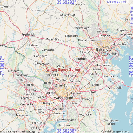
Ashton-Sandy Spring GPS coordinates[2]
39° 8' 59.136" North, 77° 0' 18.144" West
| Map corner | latitude | longitude |
|---|---|---|
| Upper-left | 39.69292°, | -77.70817° |
| Center: | 39.14976°, | -77.00504° |
| Lower-right: | 38.60238°, | -76.30192° |
| Map W x H: | 121.3×121.3 km | = 75.4×75.4mi |
| max Lat: | 71.29058° ⇑53.4% North |
| Ashton-Sandy Spring: | 39.14976° |
| min Lat: | ⇓46.6% South 19.06759° |
| min Long | Ashton-Sandy Sp | max Long |
| -171.73463° | -77.00504° | -66.98998° |
| W 80.5%⇐ | ⇒19.5% E |
Elevation
Elevation of Ashton-Sandy Spring is 153 m = 502 ft, and this is 141.8 m = 465 ft below average elevation for this country.
| Max E: |
3189 m = 10463 ft | 60.3% |
| Avg. | 294.8 m = 967 ft | |
| Ashton-Sandy Spring | 153 m = 502 ft | |
Min E: |
-60 m = -197 ft | 39.7% |
See also: United States elevation on elevation.city.
Geographical zone
Ashton-Sandy Spring is located in North temperate zone (between Tropic of Cancer and the Arctic Circle). Distance of this Northern Tropic circle is 1747.1 km =1085.6 mi to South.| Distance of | km | miles | from Ashton-Sandy Spring |
|---|---|---|---|
| North Pole | 5654 | 3513.2 | to North |
| Arctic Circle | 3048.1 | 1894 | to North |
| Tropic Cancer | 1747.1 | 1085.6 | to South |
| Equator | 4353 | 2704.8 | to South |


Nearby cities:
15 places around Ashton-Sandy Spring: (largest is in red/bold)
• Aspen Hill
9.8 km =6.1 mi,  216°
216°
• Burtonsville
7.6 km =4.7 mi,  124°
124°
• Cloverly
4.7 km =2.9 mi,  172°
172°
• Colesville
8.2 km =5.1 mi,  178°
178°
• Fairland
9.1 km =5.7 mi,  153°
153°
• Fulton
7.1 km =4.4 mi,  88°
88°
• Highland
5.2 km =3.2 mi,  51°
51°
• Layhill
7.2 km =4.5 mi,  208°
208°
• Leisure World
7.6 km =4.7 mi,  226°
226°
• Olney
5.3 km =3.3 mi,  274°
274°
• Riverside
10.7 km =6.6 mi,  75°
75°
• Rossmoor
7.7 km =4.8 mi, 228°
• Scaggsville
9.1 km =5.7 mi, 93°
• Spencerville
4.6 km =2.9 mi, 149°
• West Laurel
10.6 km =6.6 mi, 120°
Sources, notices
• [Note1] Compared only with cities in United States existing in our database
• [Src1] Map data: © OpenStreetMap contributors (CC-BY-SA)
• [Src2] Other city data from geonames.org with taken over terms of usage.
• [Src3] Geographical zone / Annual Mean Temperature by Robert A. Rohde @ Wikipedia
