Colesville geodata
Colesville (Maryland) is a populated place; located in United States in America/New_York (GMT-4) time zone. With population of 14,647 people, there are 3305 cities with bigger population in this country. Compared to other cities in United States, 54.1% of cities are located further ↑North; 80.5% of cities are located further ←West and 64.2% of cities have higher elevation than Colesville. Note1


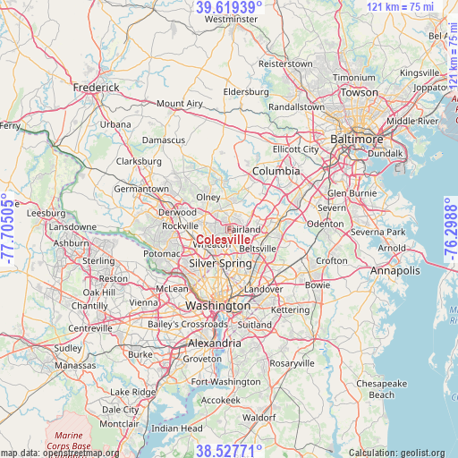
Colesville GPS coordinates[2]
39° 4' 32.376" North, 77° 0' 6.912" West
| Map corner | latitude | longitude |
|---|---|---|
| Upper-left | 39.61939°, | -77.70505° |
| Center: | 39.07566°, | -77.00192° |
| Lower-right: | 38.52771°, | -76.2988° |
| Map W x H: | 121.4×121.4 km | = 75.4×75.4mi |
| max Lat: | 71.29058° ⇑54.1% North |
| Colesville: | 39.07566° |
| min Lat: | ⇓45.9% South 19.06759° |
| min Long | Colesville | max Long |
| -171.73463° | -77.00192° | -66.98998° |
| W 80.5%⇐ | ⇒19.5% E |
Elevation
Elevation of Colesville is 132 m = 433 ft, and this is 162.8 m = 534 ft below average elevation for this country.
| Max E: |
3189 m = 10463 ft | 64.2% |
| Avg. | 294.8 m = 967 ft | |
| Colesville | 132 m = 433 ft | |
Min E: |
-60 m = -197 ft | 35.8% |
See also: United States elevation on elevation.city.
Geographical zone
Colesville is located in North temperate zone (between Tropic of Cancer and the Arctic Circle). Distance of this Northern Tropic circle is 1738.9 km =1080.5 mi to South.| Distance of | km | miles | from Colesville |
|---|---|---|---|
| North Pole | 5662.3 | 3518.4 | to North |
| Arctic Circle | 3056.4 | 1899.2 | to North |
| Tropic Cancer | 1738.9 | 1080.5 | to South |
| Equator | 4344.8 | 2699.7 | to South |


Nearby cities:
15 places around Colesville: (largest is in red/bold)
• Aspen Hill
6.2 km =3.9 mi,  274°
274°
• Burtonsville
7.2 km =4.5 mi,  56°
56°
• Calverton
6 km =3.7 mi,  109°
109°
• Cloverly
3.6 km =2.2 mi,  5°
5°
• Fairland
3.8 km =2.4 mi,  89°
89°
• Four Corners
6.2 km =3.9 mi,  188°
188°
• Glenmont
4.6 km =2.9 mi,  244°
244°
• Hillandale
6 km =3.7 mi,  156°
156°
• Kemp Mill
4.3 km =2.7 mi,  200°
200°
• Layhill
4.1 km =2.5 mi,  296°
296°
• Leisure World
6.5 km =4 mi, 297°
• Rossmoor
6.7 km =4.2 mi, 297°
• Spencerville
4.8 km =3 mi,  25°
25°
• Wheaton
6.1 km =3.8 mi,  229°
229°
• White Oak
4.1 km =2.5 mi,  169°
169°
Sources, notices
• [Note1] Compared only with cities in United States existing in our database
• [Src1] Map data: © OpenStreetMap contributors (CC-BY-SA)
• [Src2] Other city data from geonames.org with taken over terms of usage.
• [Src3] Geographical zone / Annual Mean Temperature by Robert A. Rohde @ Wikipedia
