Oxon Hill-Glassmanor geodata
Oxon Hill-Glassmanor (Maryland) is a populated place; located in United States in America/New_York (GMT-4) time zone. With population of 35,355 people, there are 1394 cities with bigger population in this country. Compared to other cities in United States, 56.6% of cities are located further ↑North; 80.7% of cities are located further ←West and 79% of cities have higher elevation than Oxon Hill-Glassmanor. Note1


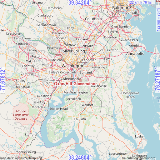
Oxon Hill-Glassmanor GPS coordinates[2]
38° 47' 46.14" North, 76° 58' 29.964" West
| Map corner | latitude | longitude |
|---|---|---|
| Upper-left | 39.34204°, | -77.67812° |
| Center: | 38.79615°, | -76.97499° |
| Lower-right: | 38.24604°, | -76.27187° |
| Map W x H: | 121.9×121.9 km | = 75.7×75.7mi |
| max Lat: | 71.29058° ⇑56.6% North |
| Oxon Hill-Glassmanor: | 38.79615° |
| min Lat: | ⇓43.4% South 19.06759° |
| min Long | Oxon Hill-Glass | max Long |
| -171.73463° | -76.97499° | -66.98998° |
| W 80.7%⇐ | ⇒19.3% E |
Elevation
Elevation of Oxon Hill-Glassmanor is 51 m = 167 ft, and this is 243.8 m = 800 ft below average elevation for this country.
| Max E: |
3189 m = 10463 ft | 79% |
| Avg. | 294.8 m = 967 ft | |
| Oxon Hill-Glassmanor | 51 m = 167 ft | |
Min E: |
-60 m = -197 ft | 21% |
See also: United States elevation on elevation.city.
Geographical zone
Oxon Hill-Glassmanor is located in North temperate zone (between Tropic of Cancer and the Arctic Circle). Distance of this Northern Tropic circle is 1707.8 km =1061.2 mi to South.| Distance of | km | miles | from Oxon Hill-Glassmanor |
|---|---|---|---|
| North Pole | 5693.3 | 3537.7 | to North |
| Arctic Circle | 3087.4 | 1918.4 | to North |
| Tropic Cancer | 1707.8 | 1061.2 | to South |
| Equator | 4313.7 | 2680.4 | to South |


Nearby cities:
15 places around Oxon Hill-Glassmanor: (largest is in red/bold)
• Alexandria
6.3 km =3.9 mi,  278°
278°
• Belle Haven
7.7 km =4.8 mi,  261°
261°
• Camp Springs
6 km =3.7 mi,  81°
81°
• Clinton
7.5 km =4.7 mi,  117°
117°
• Forest Heights
2.5 km =1.6 mi,  306°
306°
• Friendly
4.9 km =3 mi,  183°
183°
• Glassmanor
3.3 km =2.1 mi,  321°
321°
• Hillcrest Heights
4.3 km =2.7 mi,  18°
18°
• Marlow Heights
4.6 km =2.9 mi,  26°
26°
• National Harbor
3.8 km =2.4 mi,  246°
246°
• Oxon Hill
1.5 km =0.9 mi,  302°
302°
• Silver Hill
5.7 km =3.5 mi, 26°
• Suitland
7.3 km =4.5 mi,  37°
37°
• Suitland-Silver Hill
7.1 km =4.4 mi, 37°
• Temple Hills
3.2 km =2 mi,  52°
52°
Sources, notices
• [Note1] Compared only with cities in United States existing in our database
• [Src1] Map data: © OpenStreetMap contributors (CC-BY-SA)
• [Src2] Other city data from geonames.org with taken over terms of usage.
• [Src3] Geographical zone / Annual Mean Temperature by Robert A. Rohde @ Wikipedia
