Lutherville-Timonium geodata
Lutherville-Timonium (Maryland) is a populated place; located in United States in America/New_York (GMT-4) time zone. With population of 15,814 people, there are 3097 cities with bigger population in this country. Compared to other cities in United States, 51.3% of cities are located further ↑North; 82.2% of cities are located further ←West and 70% of cities have higher elevation than Lutherville-Timonium. Note1


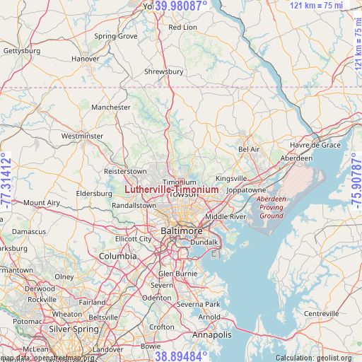
Lutherville-Timonium GPS coordinates[2]
39° 26' 23.892" North, 76° 36' 39.564" West
| Map corner | latitude | longitude |
|---|---|---|
| Upper-left | 39.98087°, | -77.31412° |
| Center: | 39.43997°, | -76.61099° |
| Lower-right: | 38.89484°, | -75.90787° |
| Map W x H: | 120.8×120.8 km | = 75.1×75.1mi |
| max Lat: | 71.29058° ⇑51.3% North |
| Lutherville-Timonium: | 39.43997° |
| min Lat: | ⇓48.7% South 19.06759° |
| min Long | Lutherville-Tim | max Long |
| -171.73463° | -76.61099° | -66.98998° |
| W 82.2%⇐ | ⇒17.8% E |
Elevation
Elevation of Lutherville-Timonium is 101 m = 331 ft, and this is 193.8 m = 636 ft below average elevation for this country.
| Max E: |
3189 m = 10463 ft | 70% |
| Avg. | 294.8 m = 967 ft | |
| Lutherville-Timonium | 101 m = 331 ft | |
Min E: |
-60 m = -197 ft | 30% |
See also: United States elevation on elevation.city.
Geographical zone
Lutherville-Timonium is located in North temperate zone (between Tropic of Cancer and the Arctic Circle). Distance of this Northern Tropic circle is 1779.4 km =1105.7 mi to South.| Distance of | km | miles | from Lutherville-Timonium |
|---|---|---|---|
| North Pole | 5621.7 | 3493.2 | to North |
| Arctic Circle | 3015.9 | 1874 | to North |
| Tropic Cancer | 1779.4 | 1105.7 | to South |
| Equator | 4385.3 | 2724.9 | to South |


Nearby cities:
15 places around Lutherville-Timonium: (largest is in red/bold)
• Arlington
11.9 km =7.4 mi,  211°
211°
• Carney
9.1 km =5.7 mi,  124°
124°
• Charles Village
13 km =8.1 mi,  180°
180°
• Cockeysville
5.4 km =3.4 mi,  328°
328°
• Garrison
13.4 km =8.3 mi,  253°
253°
• Hampton
3 km =1.9 mi,  130°
130°
• Hunt Valley
7.1 km =4.4 mi,  338°
338°
• Lutherville
2.5 km =1.6 mi, 211°
• Mays Chapel
3.4 km =2.1 mi,  257°
257°
• Overlea
11.5 km =7.1 mi,  137°
137°
• Parkville
9.3 km =5.8 mi, 138°
• Perry Hall
13 km =8.1 mi,  103°
103°
• Pikesville
12 km =7.5 mi,  232°
232°
• Timonium
0.8 km =0.5 mi, 246°
• Towson
4.3 km =2.7 mi,  169°
169°
Sources, notices
• [Note1] Compared only with cities in United States existing in our database
• [Src1] Map data: © OpenStreetMap contributors (CC-BY-SA)
• [Src2] Other city data from geonames.org with taken over terms of usage.
• [Src3] Geographical zone / Annual Mean Temperature by Robert A. Rohde @ Wikipedia
