Mays Chapel geodata
Mays Chapel (Maryland) is a populated place; located in United States in America/New_York (GMT-4) time zone. With population of 11,420 people, there are 4048 cities with bigger population in this country. Compared to other cities in United States, 51.3% of cities are located further ↑North; 82% of cities are located further ←West and 60.1% of cities have higher elevation than Mays Chapel. Note1


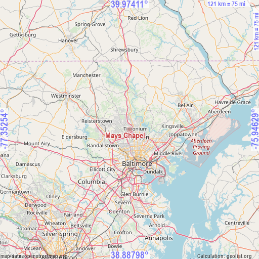
Mays Chapel GPS coordinates[2]
39° 25' 59.376" North, 76° 38' 57.876" West
| Map corner | latitude | longitude |
|---|---|---|
| Upper-left | 39.97411°, | -77.35254° |
| Center: | 39.43316°, | -76.64941° |
| Lower-right: | 38.88798°, | -75.94629° |
| Map W x H: | 120.8×120.8 km | = 75.1×75.1mi |
| max Lat: | 71.29058° ⇑51.3% North |
| Mays Chapel: | 39.43316° |
| min Lat: | ⇓48.7% South 19.06759° |
| min Long | Mays Chapel | max Long |
| -171.73463° | -76.64941° | -66.98998° |
| W 82%⇐ | ⇒18% E |
Elevation
Elevation of Mays Chapel is 154 m = 505 ft, and this is 140.8 m = 462 ft below average elevation for this country.
| Max E: |
3189 m = 10463 ft | 60.1% |
| Avg. | 294.8 m = 967 ft | |
| Mays Chapel | 154 m = 505 ft | |
Min E: |
-60 m = -197 ft | 39.9% |
See also: United States elevation on elevation.city.
Geographical zone
Mays Chapel is located in North temperate zone (between Tropic of Cancer and the Arctic Circle). Distance of this Northern Tropic circle is 1778.6 km =1105.2 mi to South.| Distance of | km | miles | from Mays Chapel |
|---|---|---|---|
| North Pole | 5622.5 | 3493.7 | to North |
| Arctic Circle | 3016.6 | 1874.4 | to North |
| Tropic Cancer | 1778.6 | 1105.2 | to South |
| Equator | 4384.6 | 2724.5 | to South |


Nearby cities:
15 places around Mays Chapel: (largest is in red/bold)
• Arlington
9.8 km =6.1 mi,  197°
197°
• Carney
11.6 km =7.2 mi,  111°
111°
• Charles Village
12.6 km =7.8 mi,  165°
165°
• Cockeysville
5.4 km =3.4 mi,  5°
5°
• Garrison
10 km =6.2 mi,  252°
252°
• Hampton
5.7 km =3.5 mi,  101°
101°
• Hunt Valley
7.4 km =4.6 mi, 5°
• Lochearn
12 km =7.5 mi,  211°
211°
• Lutherville
2.4 km =1.5 mi,  123°
123°
• Lutherville-Timonium
3.4 km =2.1 mi,  77°
77°
• Owings Mills
11.3 km =7 mi,  262°
262°
• Parkville
11.3 km =7 mi, 123°
• Pikesville
9.1 km =5.7 mi,  223°
223°
• Timonium
2.6 km =1.6 mi, 80°
• Towson
5.4 km =3.4 mi,  130°
130°
Sources, notices
• [Note1] Compared only with cities in United States existing in our database
• [Src1] Map data: © OpenStreetMap contributors (CC-BY-SA)
• [Src2] Other city data from geonames.org with taken over terms of usage.
• [Src3] Geographical zone / Annual Mean Temperature by Robert A. Rohde @ Wikipedia
