Arlington geodata
Arlington (Maryland) is a populated place; located in United States in America/New_York (GMT-4) time zone. With population of 3,065 people, there are 9533 cities with bigger population in this country. Compared to other cities in United States, 51.9% of cities are located further ↑North; 82% of cities are located further ←West and 63.7% of cities have higher elevation than Arlington. Note1


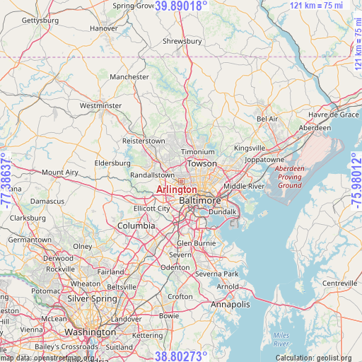
Arlington GPS coordinates[2]
39° 20' 54.852" North, 76° 40' 59.664" West
| Map corner | latitude | longitude |
|---|---|---|
| Upper-left | 39.89018°, | -77.38637° |
| Center: | 39.34857°, | -76.68324° |
| Lower-right: | 38.80273°, | -75.98012° |
| Map W x H: | 120.9×120.9 km | = 75.1×75.1mi |
| max Lat: | 71.29058° ⇑51.9% North |
| Arlington: | 39.34857° |
| min Lat: | ⇓48.1% South 19.06759° |
| min Long | Arlington | max Long |
| -171.73463° | -76.68324° | -66.98998° |
| W 82%⇐ | ⇒18% E |
Elevation
Elevation of Arlington is 135 m = 443 ft, and this is 159.8 m = 524 ft below average elevation for this country.
| Max E: |
3189 m = 10463 ft | 63.7% |
| Avg. | 294.8 m = 967 ft | |
| Arlington | 135 m = 443 ft | |
Min E: |
-60 m = -197 ft | 36.3% |
See also: United States elevation on elevation.city.
Geographical zone
Arlington is located in North temperate zone (between Tropic of Cancer and the Arctic Circle). Distance of this Northern Tropic circle is 1769.2 km =1099.3 mi to South.| Distance of | km | miles | from Arlington |
|---|---|---|---|
| North Pole | 5631.9 | 3499.5 | to North |
| Arctic Circle | 3026 | 1880.3 | to North |
| Tropic Cancer | 1769.2 | 1099.3 | to South |
| Equator | 4375.2 | 2718.6 | to South |


Nearby cities:
15 places around Arlington: (largest is in red/bold)
• Baltimore
8.9 km =5.5 mi,  136°
136°
• Catonsville
9.5 km =5.9 mi,  206°
206°
• Charles Village
6.6 km =4.1 mi,  115°
115°
• Charlestown
9.1 km =5.7 mi,  191°
191°
• Garrison
9.2 km =5.7 mi,  313°
313°
• Irvington
7.3 km =4.5 mi,  181°
181°
• Lochearn
3.5 km =2.2 mi,  255°
255°
• Lutherville
9.5 km =5.9 mi,  31°
31°
• Mays Chapel
9.8 km =6.1 mi,  17°
17°
• Milford Mill
7.5 km =4.7 mi,  269°
269°
• Mount Vernon
8.1 km =5 mi,  134°
134°
• Oaklee
9 km =5.6 mi, 180°
• Pikesville
4.4 km =2.7 mi, 310°
• Towson
9.1 km =5.7 mi,  49°
49°
• Woodlawn
4.8 km =3 mi,  233°
233°
Sources, notices
• [Note1] Compared only with cities in United States existing in our database
• [Src1] Map data: © OpenStreetMap contributors (CC-BY-SA)
• [Src2] Other city data from geonames.org with taken over terms of usage.
• [Src3] Geographical zone / Annual Mean Temperature by Robert A. Rohde @ Wikipedia
