Aptos Hills-Larkin Valley geodata
Aptos Hills-Larkin Valley (California) is a populated place; located in United States in America/Los_Angeles (GMT-7) time zone. With population of 2,381 people, there are 10901 cities with bigger population in this country. Compared to other cities in United States, 66.4% of cities are located further ↑North; 94.7% of cities are located further →East and 73% of cities have higher elevation than Aptos Hills-Larkin Valley. Note1
Current local time in Aptos Hills-Larkin Valley:
03:08 AM, TuesdayDifference from your time zone: hours


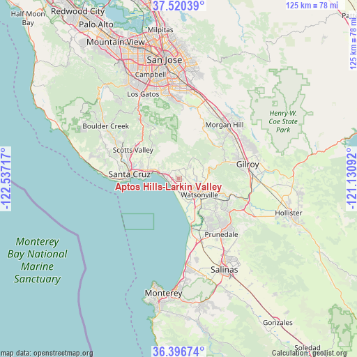
Aptos Hills-Larkin Valley GPS coordinates[2]
36° 57' 38.304" North, 121° 50' 2.544" West
| Map corner | latitude | longitude |
|---|---|---|
| Upper-left | 37.52039°, | -122.53717° |
| Center: | 36.96064°, | -121.83404° |
| Lower-right: | 36.39674°, | -121.13092° |
| Map W x H: | 124.9×124.9 km | = 77.6×77.6mi |
| max Lat: | 71.29058° ⇑66.4% North |
| Aptos Hills-Larkin Valley: | 36.96064° |
| min Lat: | ⇓33.6% South 19.06759° |
| min Long | Aptos Hills-Lar | max Long |
| -171.73463° | -121.83404° | -66.98998° |
| W 5.3%⇐ | ⇒94.7% E |
Elevation
Elevation of Aptos Hills-Larkin Valley is 83 m = 272 ft, and this is 211.8 m = 695 ft below average elevation for this country.
| Max E: |
3189 m = 10463 ft | 73% |
| Avg. | 294.8 m = 967 ft | |
| Aptos Hills-Larkin Valley | 83 m = 272 ft | |
Min E: |
-60 m = -197 ft | 27% |
See also: United States elevation on elevation.city.
Geographical zone
Aptos Hills-Larkin Valley is located in North temperate zone (between Tropic of Cancer and the Arctic Circle). Distance of this Northern Tropic circle is 1503.7 km =934.4 mi to South.| Distance of | km | miles | from Aptos Hills-Larkin Valley |
|---|---|---|---|
| North Pole | 5897.4 | 3664.5 | to North |
| Arctic Circle | 3291.5 | 2045.2 | to North |
| Tropic Cancer | 1503.7 | 934.4 | to South |
| Equator | 4109.6 | 2553.6 | to South |


Nearby cities:
15 places around Aptos Hills-Larkin Valley: (largest is in red/bold)
• Amesti
4.9 km =3 mi,  86°
86°
• Aptos
6.1 km =3.8 mi,  287°
287°
• Capitola
10.7 km =6.6 mi,  278°
278°
• Corralitos
4 km =2.5 mi,  38°
38°
• Day Valley
8.7 km =5.4 mi,  343°
343°
• Freedom
6.1 km =3.8 mi,  117°
117°
• Interlaken
9 km =5.6 mi,  96°
96°
• La Selva Beach
3.8 km =2.4 mi,  225°
225°
• Live Oak
13.3 km =8.3 mi, 281°
• Opal Cliffs
11.6 km =7.2 mi,  270°
270°
• Pajaro
9.9 km =6.2 mi,  129°
129°
• Rio Del Mar
5.9 km =3.7 mi, 278°
• Seacliff
7.4 km =4.6 mi, 281°
• Soquel
11.3 km =7 mi, 285°
• Watsonville
8.9 km =5.5 mi, 129°
Sources, notices
• [Note1] Compared only with cities in United States existing in our database
• [Src1] Map data: © OpenStreetMap contributors (CC-BY-SA)
• [Src2] Other city data from geonames.org with taken over terms of usage.
• [Src3] Geographical zone / Annual Mean Temperature by Robert A. Rohde @ Wikipedia
