Fallon Station geodata
Fallon Station (Nevada) is a populated place; located in United States in America/Los_Angeles (GMT-7) time zone. With population of 705 people, there are 18626 cities with bigger population in this country. Compared to other cities in United States, 51.4% of cities are located further ↑North; 91.7% of cities are located further →East and 94.6% of cities have lower elevation than Fallon Station. Note1


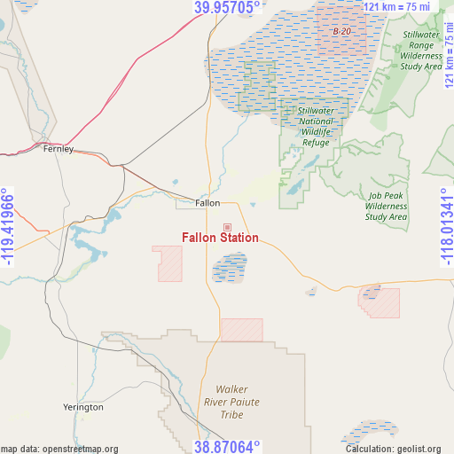
Fallon Station GPS coordinates[2]
39° 24' 57.456" North, 118° 42' 59.508" West
| Map corner | latitude | longitude |
|---|---|---|
| Upper-left | 39.95705°, | -119.41966° |
| Center: | 39.41596°, | -118.71653° |
| Lower-right: | 38.87064°, | -118.01341° |
| Map W x H: | 120.8×120.8 km | = 75.1×75.1mi |
| max Lat: | 71.29058° ⇑51.4% North |
| Fallon Station: | 39.41596° |
| min Lat: | ⇓48.6% South 19.06759° |
| min Long | Fallon Station | max Long |
| -171.73463° | -118.71653° | -66.98998° |
| W 8.3%⇐ | ⇒91.7% E |
Elevation
Elevation of Fallon Station is 1203 m = 3947 ft, and this is 908.2 m = 2980 ft above average elevation for this country.
| Max E: |
3189 m = 10463 ft | 5.4% |
| Fallon Station | 1203 m 3947 ft | |
| Avg. | 294.8 m = 967 ft | |
Min E: |
-60 m = -197 ft | 94.6% |
See also: United States elevation on elevation.city.
Geographical zone
Fallon Station is located in North temperate zone (between Tropic of Cancer and the Arctic Circle). Distance of this Northern Tropic circle is 1776.7 km =1104 mi to South.| Distance of | km | miles | from Fallon Station |
|---|---|---|---|
| North Pole | 5624.4 | 3494.8 | to North |
| Arctic Circle | 3018.5 | 1875.6 | to North |
| Tropic Cancer | 1776.7 | 1104 | to South |
| Equator | 4382.6 | 2723.2 | to South |


Nearby cities:
15 places around Fallon Station: (largest is in red/bold)
• Dayton
78 km =48.5 mi,  255°
255°
• Fallon
8.3 km =5.2 mi,  320°
320°
• Fernley
50.6 km =31.4 mi,  294°
294°
• Lovelock
87.4 km =54.3 mi,  13°
13°
• Schurz
52.4 km =32.6 mi,  188°
188°
• Silver Springs
43.6 km =27.1 mi,  269°
269°
• Smith
86.4 km =53.7 mi,  217°
217°
• Smith Valley
88.7 km =55.1 mi, 217°
• Spanish Springs
88.8 km =55.2 mi, 286°
• Sparks
89.9 km =55.9 mi,  278°
278°
• Stagecoach
56.7 km =35.2 mi, 265°
• Sun Valley
93.1 km =57.8 mi, 282°
• Virginia City
81.1 km =50.4 mi, 261°
• Wadsworth
54.5 km =33.9 mi,  296°
296°
• Yerington
61.4 km =38.2 mi, 218°
Sources, notices
• [Note1] Compared only with cities in United States existing in our database
• [Src1] Map data: © OpenStreetMap contributors (CC-BY-SA)
• [Src2] Other city data from geonames.org with taken over terms of usage.
• [Src3] Geographical zone / Annual Mean Temperature by Robert A. Rohde @ Wikipedia
