Sparks geodata
Sparks (Nevada) is a populated place; located in United States in America/Los_Angeles (GMT-7) time zone. With population of 96,094 people, there are 372 cities with bigger population in this country. Compared to other cities in United States, 50.6% of cities are located further ↑North; 92.6% of cities are located further →East and 95.6% of cities have lower elevation than Sparks. Note1


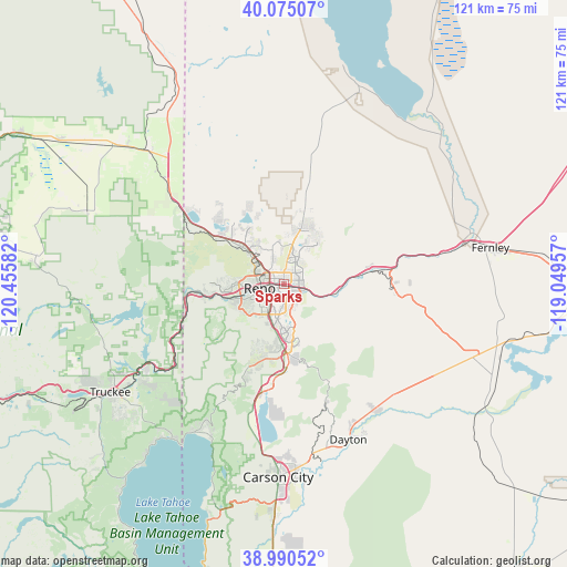
Sparks GPS coordinates[2]
39° 32' 5.676" North, 119° 45' 9.684" West
| Map corner | latitude | longitude |
|---|---|---|
| Upper-left | 40.07507°, | -120.45582° |
| Center: | 39.53491°, | -119.75269° |
| Lower-right: | 38.99052°, | -119.04957° |
| Map W x H: | 120.6×120.6 km | = 74.9×74.9mi |
| max Lat: | 71.29058° ⇑50.6% North |
| Sparks: | 39.53491° |
| min Lat: | ⇓49.4% South 19.06759° |
| min Long | Sparks | max Long |
| -171.73463° | -119.75269° | -66.98998° |
| W 7.4%⇐ | ⇒92.6% E |
Elevation
Elevation of Sparks is 1348 m = 4423 ft, and this is 1053.2 m = 3455 ft above average elevation for this country.
| Max E: |
3189 m = 10463 ft | 4.4% |
| Sparks | 1348 m 4423 ft | |
| Avg. | 294.8 m = 967 ft | |
Min E: |
-60 m = -197 ft | 95.6% |
See also: Sparks elevation on elevation.city.
Geographical zone
Sparks is located in North temperate zone (between Tropic of Cancer and the Arctic Circle). Distance of this Northern Tropic circle is 1790 km =1112.3 mi to South.| Distance of | km | miles | from Sparks |
|---|---|---|---|
| North Pole | 5611.2 | 3486.6 | to North |
| Arctic Circle | 3005.3 | 1867.4 | to North |
| Tropic Cancer | 1790 | 1112.3 | to South |
| Equator | 4395.9 | 2731.5 | to South |


Nearby cities:
15 places around Sparks: (largest is in red/bold)
• Carson City
41.3 km =25.7 mi,  181°
181°
• Cold Springs
25.1 km =15.6 mi,  310°
310°
• Dayton
35.8 km =22.2 mi,  157°
157°
• Golden Valley
11 km =6.8 mi,  324°
324°
• Incline Village
36.8 km =22.9 mi,  210°
210°
• Kings Beach
40.6 km =25.2 mi,  215°
215°
• Lemmon Valley
13.7 km =8.5 mi,  325°
325°
• Mogul
15.1 km =9.4 mi,  261°
261°
• Reno
5.3 km =3.3 mi, 263°
• Spanish Springs
13.3 km =8.3 mi,  16°
16°
• Stagecoach
37.1 km =23.1 mi,  118°
118°
• Sun Valley
7.1 km =4.4 mi,  343°
343°
• Verdi
20.3 km =12.6 mi, 264°
• Virginia City
26.6 km =16.5 mi, 160°
• Wadsworth
41.5 km =25.8 mi,  74°
74°
Sources, notices
• [Note1] Compared only with cities in United States existing in our database
• [Src1] Map data: © OpenStreetMap contributors (CC-BY-SA)
• [Src2] Other city data from geonames.org with taken over terms of usage.
• [Src3] Geographical zone / Annual Mean Temperature by Robert A. Rohde @ Wikipedia
