Florence-Graham geodata
Florence-Graham (California) is a populated place; located in United States in America/Los_Angeles (GMT-7) time zone. With population of 63,387 people, there are 688 cities with bigger population in this country. Compared to other cities in United States, 80.5% of cities are located further ↑North; 91.2% of cities are located further →East and 80.1% of cities have higher elevation than Florence-Graham. Note1


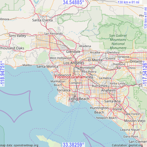
Florence-Graham GPS coordinates[2]
33° 58' 3.792" North, 118° 14' 39.768" West
| Map corner | latitude | longitude |
|---|---|---|
| Upper-left | 34.54885°, | -118.94751° |
| Center: | 33.96772°, | -118.24438° |
| Lower-right: | 33.38259°, | -117.54126° |
| Map W x H: | 129.7×129.7 km | = 80.6×80.6mi |
| max Lat: | 71.29058° ⇑80.5% North |
| Florence-Graham: | 33.96772° |
| min Lat: | ⇓19.5% South 19.06759° |
| min Long | Florence-Graham | max Long |
| -171.73463° | -118.24438° | -66.98998° |
| W 8.8%⇐ | ⇒91.2% E |
Elevation
Elevation of Florence-Graham is 46 m = 151 ft, and this is 248.8 m = 816 ft below average elevation for this country.
| Max E: |
3189 m = 10463 ft | 80.1% |
| Avg. | 294.8 m = 967 ft | |
| Florence-Graham | 46 m = 151 ft | |
Min E: |
-60 m = -197 ft | 19.9% |
See also: Florence-Graham elevation on elevation.city.
Geographical zone
Florence-Graham is located in North temperate zone (between Tropic of Cancer and the Arctic Circle). Distance of this Northern Tropic circle is 1170.9 km =727.6 mi to South.| Distance of | km | miles | from Florence-Graham |
|---|---|---|---|
| North Pole | 6230.2 | 3871.3 | to North |
| Arctic Circle | 3624.3 | 2252 | to North |
| Tropic Cancer | 1170.9 | 727.6 | to South |
| Equator | 3776.9 | 2346.9 | to South |


Nearby cities:
15 places around Florence-Graham: (largest is in red/bold)
• Bell
5.4 km =3.4 mi,  78°
78°
• Bell Gardens
8.6 km =5.3 mi,  91°
91°
• Boyle Heights
8.2 km =5.1 mi,  26°
26°
• Commerce
8.6 km =5.3 mi,  64°
64°
• Compton
8.3 km =5.2 mi,  164°
164°
• Cudahy
5.5 km =3.4 mi,  98°
98°
• Huntington Park
2.4 km =1.5 mi,  48°
48°
• Lynwood
5.2 km =3.2 mi,  143°
143°
• Maywood
5.8 km =3.6 mi,  68°
68°
• South Gate
3.3 km =2.1 mi,  115°
115°
• Walnut Park
1.8 km =1.1 mi, 88°
• West Athens
7.3 km =4.5 mi,  227°
227°
• West Rancho Dominguez
8.6 km =5.3 mi,  196°
196°
• Westmont
6.1 km =3.8 mi,  241°
241°
• Willowbrook
5.7 km =3.5 mi,  189°
189°
Sources, notices
• [Note1] Compared only with cities in United States existing in our database
• [Src1] Map data: © OpenStreetMap contributors (CC-BY-SA)
• [Src2] Other city data from geonames.org with taken over terms of usage.
• [Src3] Geographical zone / Annual Mean Temperature by Robert A. Rohde @ Wikipedia
