Bell Gardens geodata
Bell Gardens (California) is a populated place; located in United States in America/Los_Angeles (GMT-7) time zone. With population of 43,106 people, there are 1109 cities with bigger population in this country. Compared to other cities in United States, 80.5% of cities are located further ↑North; 91.1% of cities are located further →East and 82.3% of cities have higher elevation than Bell Gardens. Note1


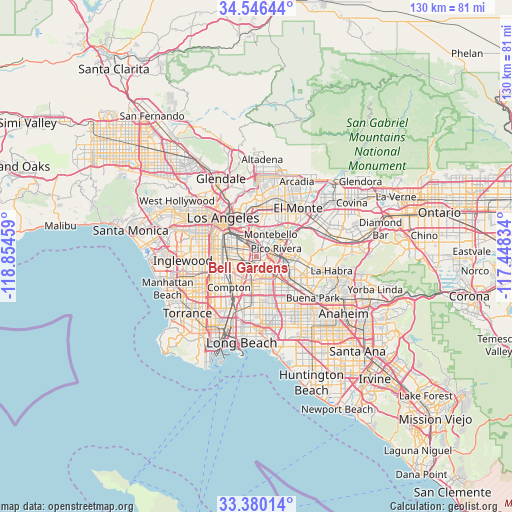
Bell Gardens GPS coordinates[2]
33° 57' 55.044" North, 118° 9' 5.256" West
| Map corner | latitude | longitude |
|---|---|---|
| Upper-left | 34.54644°, | -118.85459° |
| Center: | 33.96529°, | -118.15146° |
| Lower-right: | 33.38014°, | -117.44834° |
| Map W x H: | 129.7×129.7 km | = 80.6×80.6mi |
| max Lat: | 71.29058° ⇑80.5% North |
| Bell Gardens: | 33.96529° |
| min Lat: | ⇓19.5% South 19.06759° |
| min Long | Bell Gardens | max Long |
| -171.73463° | -118.15146° | -66.98998° |
| W 8.9%⇐ | ⇒91.1% E |
Elevation
Elevation of Bell Gardens is 37 m = 121 ft, and this is 257.8 m = 846 ft below average elevation for this country.
| Max E: |
3189 m = 10463 ft | 82.3% |
| Avg. | 294.8 m = 967 ft | |
| Bell Gardens | 37 m = 121 ft | |
Min E: |
-60 m = -197 ft | 17.7% |
See also: Bell Gardens elevation on elevation.city.
Geographical zone
Bell Gardens is located in North temperate zone (between Tropic of Cancer and the Arctic Circle). Distance of this Northern Tropic circle is 1170.7 km =727.4 mi to South.| Distance of | km | miles | from Bell Gardens |
|---|---|---|---|
| North Pole | 6230.5 | 3871.5 | to North |
| Arctic Circle | 3624.6 | 2252.2 | to North |
| Tropic Cancer | 1170.7 | 727.4 | to South |
| Equator | 3776.6 | 2346.7 | to South |


Nearby cities:
15 places around Bell Gardens: (largest is in red/bold)
• Bell
3.5 km =2.2 mi,  292°
292°
• Commerce
4 km =2.5 mi,  348°
348°
• Cudahy
3.2 km =2 mi,  260°
260°
• Downey
3.3 km =2.1 mi,  148°
148°
• East Los Angeles
6.8 km =4.2 mi,  343°
343°
• Huntington Park
7 km =4.3 mi, 285°
• Lynwood
6.8 km =4.2 mi,  234°
234°
• Maywood
3.9 km =2.4 mi,  307°
307°
• Montebello
6.5 km =4 mi,  40°
40°
• Paramount
8.5 km =5.3 mi,  185°
185°
• Pico Rivera
5.4 km =3.4 mi,  68°
68°
• Santa Fe Springs
6.4 km =4 mi,  108°
108°
• South Gate
5.7 km =3.5 mi, 258°
• Walnut Park
6.8 km =4.2 mi,  272°
272°
• West Whittier-Los Nietos
7.7 km =4.8 mi,  81°
81°
Sources, notices
• [Note1] Compared only with cities in United States existing in our database
• [Src1] Map data: © OpenStreetMap contributors (CC-BY-SA)
• [Src2] Other city data from geonames.org with taken over terms of usage.
• [Src3] Geographical zone / Annual Mean Temperature by Robert A. Rohde @ Wikipedia
