Aloha geodata
Aloha (Oregon) is a populated place; located in United States in America/Los_Angeles (GMT-7) time zone. With population of 49,425 people, there are 966 cities with bigger population in this country. Compared to other cities in United States, 94% of cities are located further ↓South; 97.6% of cities are located further →East and 76.3% of cities have higher elevation than Aloha. Note1


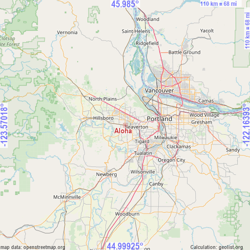
Aloha GPS coordinates[2]
45° 29' 39.408" North, 122° 52' 1.38" West
| Map corner | latitude | longitude |
|---|---|---|
| Upper-left | 45.985°, | -123.57018° |
| Center: | 45.49428°, | -122.86705° |
| Lower-right: | 44.99925°, | -122.16393° |
| Map W x H: | 109.6×109.6 km | = 68.1×68.1mi |
| max Lat: | 71.29058° ⇑6% North |
| Aloha: | 45.49428° |
| min Lat: | ⇓94% South 19.06759° |
| min Long | Aloha | max Long |
| -171.73463° | -122.86705° | -66.98998° |
| W 2.4%⇐ | ⇒97.6% E |
Elevation
Elevation of Aloha is 64 m = 210 ft, and this is 230.8 m = 757 ft below average elevation for this country.
| Max E: |
3189 m = 10463 ft | 76.3% |
| Avg. | 294.8 m = 967 ft | |
| Aloha | 64 m = 210 ft | |
Min E: |
-60 m = -197 ft | 23.7% |
See also: Aloha elevation on elevation.city.
Geographical zone
Aloha is located in North temperate zone (between Tropic of Cancer and the Arctic Circle). Distance of this North polar circle is 2342.7 km =1455.7 mi to North.| Distance of | km | miles | from Aloha |
|---|---|---|---|
| North Pole | 4948.6 | 3074.9 | to North |
| Arctic Circle | 2342.7 | 1455.7 | to North |
| Tropic Cancer | 2452.6 | 1524 | to South |
| Equator | 5058.5 | 3143.2 | to South |


Nearby cities:
15 places around Aloha: (largest is in red/bold)
• Beaverton
5 km =3.1 mi,  99°
99°
• Bethany
7.1 km =4.4 mi,  359°
359°
• Cedar Hills
5.5 km =3.4 mi,  77°
77°
• Cedar Mill
5.5 km =3.4 mi,  52°
52°
• Garden Home-Whitford
9.1 km =5.7 mi,  111°
111°
• Hillsboro
10.1 km =6.3 mi,  288°
288°
• King City
11.3 km =7 mi,  154°
154°
• Metzger
10 km =6.2 mi,  122°
122°
• Oak Hills
5.6 km =3.5 mi,  21°
21°
• Raleigh Hills
8.3 km =5.2 mi, 100°
• Rockcreek
6.3 km =3.9 mi,  352°
352°
• Tigard
10.2 km =6.3 mi,  133°
133°
• West Haven
8 km =5 mi,  71°
71°
• West Haven-Sylvan
8.1 km =5 mi, 72°
• West Slope
8 km =5 mi,  86°
86°
Sources, notices
• [Note1] Compared only with cities in United States existing in our database
• [Src1] Map data: © OpenStreetMap contributors (CC-BY-SA)
• [Src2] Other city data from geonames.org with taken over terms of usage.
• [Src3] Geographical zone / Annual Mean Temperature by Robert A. Rohde @ Wikipedia
