Yosemite Valley geodata
Yosemite Valley (California) is a populated place; located in United States in America/Los_Angeles (GMT-7) time zone. With population of 1,035 people, there are 16053 cities with bigger population in this country. Compared to other cities in United States, 63% of cities are located further ↑North; 92.5% of cities are located further →East and 94.7% of cities have lower elevation than Yosemite Valley. Note1


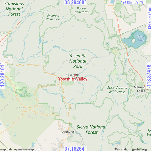
Yosemite Valley GPS coordinates[2]
37° 44' 26.7" North, 119° 34' 40.368" West
| Map corner | latitude | longitude |
|---|---|---|
| Upper-left | 38.29468°, | -120.28101° |
| Center: | 37.74075°, | -119.57788° |
| Lower-right: | 37.18264°, | -118.87476° |
| Map W x H: | 123.6×123.6 km | = 76.8×76.8mi |
| max Lat: | 71.29058° ⇑63% North |
| Yosemite Valley: | 37.74075° |
| min Lat: | ⇓37% South 19.06759° |
| min Long | Yosemite Valley | max Long |
| -171.73463° | -119.57788° | -66.98998° |
| W 7.5%⇐ | ⇒92.5% E |
Elevation
Elevation of Yosemite Valley is 1227 m = 4026 ft, and this is 932.2 m = 3058 ft above average elevation for this country.
| Max E: |
3189 m = 10463 ft | 5.3% |
| Yosemite Valley | 1227 m 4026 ft | |
| Avg. | 294.8 m = 967 ft | |
Min E: |
-60 m = -197 ft | 94.7% |
See also: United States elevation on elevation.city.
Geographical zone
Yosemite Valley is located in North temperate zone (between Tropic of Cancer and the Arctic Circle). Distance of this Northern Tropic circle is 1590.5 km =988.3 mi to South.| Distance of | km | miles | from Yosemite Valley |
|---|---|---|---|
| North Pole | 5810.7 | 3610.6 | to North |
| Arctic Circle | 3204.8 | 1991.4 | to North |
| Tropic Cancer | 1590.5 | 988.3 | to South |
| Equator | 4196.4 | 2607.5 | to South |


Nearby cities:
15 places around Yosemite Valley: (largest is in red/bold)
• Ahwahnee
43.7 km =27.2 mi,  197°
197°
• Bass Lake
46.3 km =28.8 mi,  178°
178°
• Bootjack
41 km =25.5 mi,  221°
221°
• Catheys Valley
57.2 km =35.5 mi,  233°
233°
• Coarsegold
54.3 km =33.7 mi,  191°
191°
• Greeley Hill
48.5 km =30.1 mi,  270°
270°
• Groveland
58.6 km =36.4 mi,  280°
280°
• June Lake
44.4 km =27.6 mi,  84°
84°
• Mammoth Lakes
54.3 km =33.7 mi,  100°
100°
• Mariposa
44.5 km =27.7 mi, 230°
• Mi-Wuk Village
64.4 km =40 mi,  304°
304°
• Midpines
37.2 km =23.1 mi, 234°
• Oakhurst
46.3 km =28.8 mi, 187°
• Tuolumne City
63.3 km =39.3 mi,  292°
292°
• Yosemite Lakes
63.5 km =39.5 mi, 195°
Sources, notices
• [Note1] Compared only with cities in United States existing in our database
• [Src1] Map data: © OpenStreetMap contributors (CC-BY-SA)
• [Src2] Other city data from geonames.org with taken over terms of usage.
• [Src3] Geographical zone / Annual Mean Temperature by Robert A. Rohde @ Wikipedia
