Squaw Valley geodata
Squaw Valley (California) is a populated place; located in United States in America/Los_Angeles (GMT-7) time zone. With population of 3,162 people, there are 9356 cities with bigger population in this country. Compared to other cities in United States, 67.1% of cities are located further ↑North; 92.1% of cities are located further →East and 87.8% of cities have lower elevation than Squaw Valley. Note1


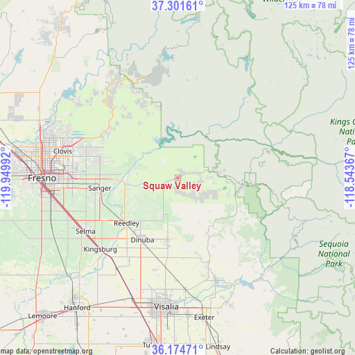
Squaw Valley GPS coordinates[2]
36° 44' 24.828" North, 119° 14' 48.444" West
| Map corner | latitude | longitude |
|---|---|---|
| Upper-left | 37.30161°, | -119.94992° |
| Center: | 36.74023°, | -119.24679° |
| Lower-right: | 36.17471°, | -118.54367° |
| Map W x H: | 125.3×125.3 km | = 77.9×77.9mi |
| max Lat: | 71.29058° ⇑67.1% North |
| Squaw Valley: | 36.74023° |
| min Lat: | ⇓32.9% South 19.06759° |
| min Long | Squaw Valley | max Long |
| -171.73463° | -119.24679° | -66.98998° |
| W 7.9%⇐ | ⇒92.1% E |
Elevation
Elevation of Squaw Valley is 499 m = 1637 ft, and this is 204.2 m = 670 ft above average elevation for this country.
| Max E: |
3189 m = 10463 ft | 12.2% |
| Squaw Valley | 499 m 1637 ft | |
| Avg. | 294.8 m = 967 ft | |
Min E: |
-60 m = -197 ft | 87.8% |
See also: United States elevation on elevation.city.
Geographical zone
Squaw Valley is located in North temperate zone (between Tropic of Cancer and the Arctic Circle). Distance of this Northern Tropic circle is 1479.2 km =919.1 mi to South.| Distance of | km | miles | from Squaw Valley |
|---|---|---|---|
| North Pole | 5921.9 | 3679.7 | to North |
| Arctic Circle | 3316 | 2060.5 | to North |
| Tropic Cancer | 1479.2 | 919.1 | to South |
| Equator | 4085.1 | 2538.4 | to South |


Nearby cities:
15 places around Squaw Valley: (largest is in red/bold)
• Cutler
24.4 km =15.2 mi,  188°
188°
• Del Rey
32.2 km =20 mi,  253°
253°
• Dinuba
25.2 km =15.7 mi,  209°
209°
• Kingsburg
37.2 km =23.1 mi,  227°
227°
• London
34.2 km =21.3 mi, 210°
• Minkler
18.9 km =11.7 mi,  264°
264°
• Orange Cove
14.2 km =8.8 mi,  204°
204°
• Orosi
22 km =13.7 mi, 189°
• Parlier
28.8 km =17.9 mi,  240°
240°
• Reedley
24.2 km =15 mi, 228°
• Sanger
27.8 km =17.3 mi, 262°
• Selma
37.6 km =23.4 mi, 239°
• Sultana
23.2 km =14.4 mi, 201°
• Traver
38.2 km =23.7 mi, 213°
• Woodlake
38.7 km =24 mi,  159°
159°
Sources, notices
• [Note1] Compared only with cities in United States existing in our database
• [Src1] Map data: © OpenStreetMap contributors (CC-BY-SA)
• [Src2] Other city data from geonames.org with taken over terms of usage.
• [Src3] Geographical zone / Annual Mean Temperature by Robert A. Rohde @ Wikipedia
