Downieville-Lawson-Dumont geodata
Downieville-Lawson-Dumont (Colorado) is a populated place; located in United States in America/Denver (GMT-6) time zone. With population of 594 people, there are 19769 cities with bigger population in this country. Compared to other cities in United States, 51.2% of cities are located further ↓South; 83.7% of cities are located further →East and 99.8% of cities have lower elevation than Downieville-Lawson-Dumont. Note1
Current local time in Downieville-Lawson-Dumont:
01:55 AM, WednesdayDifference from your time zone: hours


Downieville-Lawson-Dumont GPS coordinates[2]
39° 45' 52.884" North, 105° 37' 3.144" West
| Map corner | latitude | longitude |
|---|---|---|
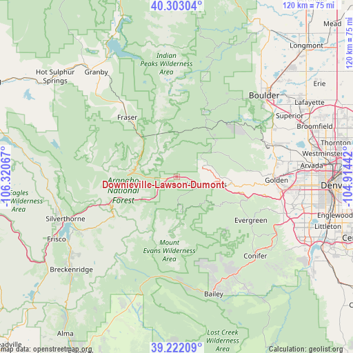
| Upper-left | 40.30304°, | -106.32067° |
| Center: | 39.76469°, | -105.61754° |
| Lower-right: | 39.22209°, | -104.91442° |
| Map W x H: | 120.2×120.2 km | = 74.7×74.7mi |
| max Lat: | 71.29058° ⇑48.8% North |
| Downieville-Lawson-Dumont: | 39.76469° |
| min Lat: | ⇓51.2% South 19.06759° |
| min Long | Downieville-Law | max Long |
| -171.73463° | -105.61754° | -66.98998° |
| W 16.3%⇐ | ⇒83.7% E |
Elevation
Elevation of Downieville-Lawson-Dumont is 2461 m = 8074 ft, and this is 2166.2 m = 7107 ft above average elevation for this country.
| Max E: |
3189 m = 10463 ft | 0.2% |
| Downieville-Lawson-Dumont | 2461 m 8074 ft | |
| Avg. | 294.8 m = 967 ft | |
Min E: |
-60 m = -197 ft | 99.8% |
See also: United States elevation on elevation.city.
Geographical zone
Downieville-Lawson-Dumont is located in North temperate zone (between Tropic of Cancer and the Arctic Circle). Distance of this Northern Tropic circle is 1815.5 km =1128.1 mi to South.| Distance of | km | miles | from Downieville-Lawson-Dumont |
|---|---|---|---|
| North Pole | 5585.6 | 3470.7 | to North |
| Arctic Circle | 2979.8 | 1851.6 | to North |
| Tropic Cancer | 1815.5 | 1128.1 | to South |
| Equator | 4421.4 | 2747.3 | to South |


Nearby cities:
15 places around Downieville-Lawson-Dumont: (largest is in red/bold)
• Central City
9.8 km =6.1 mi,  64°
64°
• Coal Creek
25.9 km =16.1 mi,  52°
52°
• Eldorado Springs
34.5 km =21.4 mi, 57°
• Evergreen
29.6 km =18.4 mi,  119°
119°
• Fraser
26.3 km =16.3 mi,  319°
319°
• Genesee
30.8 km =19.1 mi,  106°
106°
• Georgetown
9.4 km =5.8 mi,  226°
226°
• Golden
33.9 km =21.1 mi,  91°
91°
• Idaho Springs
9.2 km =5.7 mi, 105°
• Indian Hills
36.5 km =22.7 mi, 116°
• Keystone
36.6 km =22.7 mi,  239°
239°
• Kittredge
29.8 km =18.5 mi, 114°
• Nederland
23.7 km =14.7 mi,  22°
22°
• Upper Bear Creek
23.2 km =14.4 mi,  132°
132°
• Winter Park
18.8 km =11.7 mi, 318°
Sources, notices
• [Note1] Compared only with cities in United States existing in our database
• [Src1] Map data: © OpenStreetMap contributors (CC-BY-SA)
• [Src2] Other city data from geonames.org with taken over terms of usage.
• [Src3] Geographical zone / Annual Mean Temperature by Robert A. Rohde @ Wikipedia
