Upper Bear Creek geodata
Upper Bear Creek (Colorado) is a populated place; located in United States in America/Denver (GMT-6) time zone. With population of 1,059 people, there are 15906 cities with bigger population in this country. Compared to other cities in United States, 50.1% of cities are located further ↓South; 83.6% of cities are located further →East and 99.8% of cities have lower elevation than Upper Bear Creek. Note1


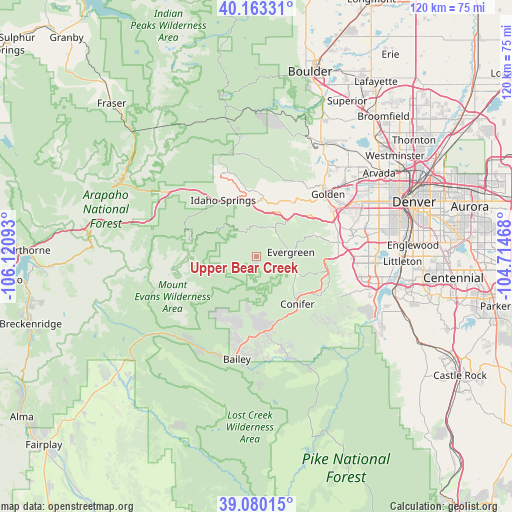
Upper Bear Creek GPS coordinates[2]
39° 37' 25.86" North, 105° 25' 4.08" West
| Map corner | latitude | longitude |
|---|---|---|
| Upper-left | 40.16331°, | -106.12093° |
| Center: | 39.62385°, | -105.4178° |
| Lower-right: | 39.08015°, | -104.71468° |
| Map W x H: | 120.4×120.4 km | = 74.8×74.8mi |
| max Lat: | 71.29058° ⇑49.9% North |
| Upper Bear Creek: | 39.62385° |
| min Lat: | ⇓50.1% South 19.06759° |
| min Long | Upper Bear Cree | max Long |
| -171.73463° | -105.4178° | -66.98998° |
| W 16.4%⇐ | ⇒83.6% E |
Elevation
Elevation of Upper Bear Creek is 2360 m = 7743 ft, and this is 2065.2 m = 6776 ft above average elevation for this country.
| Max E: |
3189 m = 10463 ft | 0.2% |
| Upper Bear Creek | 2360 m 7743 ft | |
| Avg. | 294.8 m = 967 ft | |
Min E: |
-60 m = -197 ft | 99.8% |
See also: United States elevation on elevation.city.
Geographical zone
Upper Bear Creek is located in North temperate zone (between Tropic of Cancer and the Arctic Circle). Distance of this Northern Tropic circle is 1799.8 km =1118.3 mi to South.| Distance of | km | miles | from Upper Bear Creek |
|---|---|---|---|
| North Pole | 5601.3 | 3480.5 | to North |
| Arctic Circle | 2995.4 | 1861.3 | to North |
| Tropic Cancer | 1799.8 | 1118.3 | to South |
| Equator | 4405.8 | 2737.6 | to South |


Nearby cities:
15 places around Upper Bear Creek: (largest is in red/bold)
• Applewood
26.4 km =16.4 mi,  55°
55°
• Aspen Park
14.1 km =8.8 mi,  131°
131°
• Central City
21.4 km =13.3 mi,  337°
337°
• Columbine
30.1 km =18.7 mi,  97°
97°
• Downieville-Lawson-Dumont
23.2 km =14.4 mi,  312°
312°
• Evergreen
8.7 km =5.4 mi,  83°
83°
• Genesee
14.2 km =8.8 mi, 60°
• Georgetown
25.6 km =15.9 mi,  290°
290°
• Golden
22.3 km =13.9 mi,  48°
48°
• Idaho Springs
15.5 km =9.6 mi,  328°
328°
• Indian Hills
15.5 km =9.6 mi,  92°
92°
• Ken Caryl
26.7 km =16.6 mi, 101°
• Kittredge
10.7 km =6.6 mi,  71°
71°
• Lakewood
30.2 km =18.8 mi, 72°
• West Pleasant View
23.8 km =14.8 mi, 59°
Sources, notices
• [Note1] Compared only with cities in United States existing in our database
• [Src1] Map data: © OpenStreetMap contributors (CC-BY-SA)
• [Src2] Other city data from geonames.org with taken over terms of usage.
• [Src3] Geographical zone / Annual Mean Temperature by Robert A. Rohde @ Wikipedia
