Otis Orchards-East Farms geodata
Otis Orchards-East Farms (Washington) is a populated place; located in United States in America/Los_Angeles (GMT-7) time zone. With population of 6,220 people, there are 6262 cities with bigger population in this country. Compared to other cities in United States, 98.1% of cities are located further ↓South; 89.9% of cities are located further →East and 90.2% of cities have lower elevation than Otis Orchards-East Farms. Note1
Current local time in Otis Orchards-East Farms:
11:05 AM, TuesdayDifference from your time zone: hours


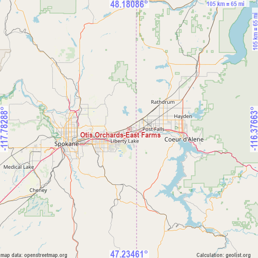
Otis Orchards-East Farms GPS coordinates[2]
47° 42' 35.568" North, 117° 4' 47.1" West
| Map corner | latitude | longitude |
|---|---|---|
| Upper-left | 48.18086°, | -117.78288° |
| Center: | 47.70988°, | -117.07975° |
| Lower-right: | 47.23461°, | -116.37663° |
| Map W x H: | 105.2×105.2 km | = 65.4×65.4mi |
| max Lat: | 71.29058° ⇑1.9% North |
| Otis Orchards-East Farms: | 47.70988° |
| min Lat: | ⇓98.1% South 19.06759° |
| min Long | Otis Orchards-E | max Long |
| -171.73463° | -117.07975° | -66.98998° |
| W 10.1%⇐ | ⇒89.9% E |
Elevation
Elevation of Otis Orchards-East Farms is 634 m = 2080 ft, and this is 339.2 m = 1113 ft above average elevation for this country.
| Max E: |
3189 m = 10463 ft | 9.8% |
| Otis Orchards-East Farms | 634 m 2080 ft | |
| Avg. | 294.8 m = 967 ft | |
Min E: |
-60 m = -197 ft | 90.2% |
See also: United States elevation on elevation.city.
Geographical zone
Otis Orchards-East Farms is located in North temperate zone (between Tropic of Cancer and the Arctic Circle). Distance of this North polar circle is 2096.3 km =1302.6 mi to North.| Distance of | km | miles | from Otis Orchards-East Farms |
|---|---|---|---|
| North Pole | 4702.2 | 2921.8 | to North |
| Arctic Circle | 2096.3 | 1302.6 | to North |
| Tropic Cancer | 2698.9 | 1677 | to South |
| Equator | 5304.8 | 3296.2 | to South |


Nearby cities:
15 places around Otis Orchards-East Farms: (largest is in red/bold)
• Coeur d'Alene
22.7 km =14.1 mi,  99°
99°
• Dalton Gardens
23.3 km =14.5 mi,  84°
84°
• Dishman
15.7 km =9.8 mi,  249°
249°
• Green Bluff
19.4 km =12.1 mi,  312°
312°
• Hauser
8 km =5 mi,  28°
28°
• Hayden
22.8 km =14.2 mi,  74°
74°
• Liberty Lake
4.7 km =2.9 mi,  217°
217°
• Mead
21.5 km =13.4 mi,  287°
287°
• Millwood
15.5 km =9.6 mi,  258°
258°
• Opportunity
13.7 km =8.5 mi,  240°
240°
• Post Falls
9.6 km =6 mi, 84°
• Rathdrum
17.8 km =11.1 mi,  50°
50°
• Spokane Valley
12.6 km =7.8 mi, 251°
• Trentwood
9.9 km =6.2 mi, 261°
• Veradale
11.6 km =7.2 mi, 235°
Sources, notices
• [Note1] Compared only with cities in United States existing in our database
• [Src1] Map data: © OpenStreetMap contributors (CC-BY-SA)
• [Src2] Other city data from geonames.org with taken over terms of usage.
• [Src3] Geographical zone / Annual Mean Temperature by Robert A. Rohde @ Wikipedia
