Rathdrum geodata
Rathdrum (Idaho) is a populated place; located in United States in America/Los_Angeles (GMT-7) time zone. With population of 7,538 people, there are 5519 cities with bigger population in this country. Compared to other cities in United States, 98.3% of cities are located further ↓South; 89.6% of cities are located further →East and 90.6% of cities have lower elevation than Rathdrum. Note1


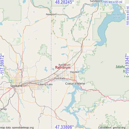
Rathdrum GPS coordinates[2]
47° 48' 44.64" North, 116° 53' 47.724" West
| Map corner | latitude | longitude |
|---|---|---|
| Upper-left | 48.28245°, | -117.59972° |
| Center: | 47.8124°, | -116.89659° |
| Lower-right: | 47.33806°, | -116.19347° |
| Map W x H: | 105×105 km | = 65.2×65.2mi |
| max Lat: | 71.29058° ⇑1.7% North |
| Rathdrum: | 47.8124° |
| min Lat: | ⇓98.3% South 19.06759° |
| min Long | Rathdrum | max Long |
| -171.73463° | -116.89659° | -66.98998° |
| W 10.4%⇐ | ⇒89.6% E |
Elevation
Elevation of Rathdrum is 671 m = 2201 ft, and this is 376.2 m = 1234 ft above average elevation for this country.
| Max E: |
3189 m = 10463 ft | 9.4% |
| Rathdrum | 671 m 2201 ft | |
| Avg. | 294.8 m = 967 ft | |
Min E: |
-60 m = -197 ft | 90.6% |
See also: United States elevation on elevation.city.
Geographical zone
Rathdrum is located in North temperate zone (between Tropic of Cancer and the Arctic Circle). Distance of this North polar circle is 2084.9 km =1295.5 mi to North.| Distance of | km | miles | from Rathdrum |
|---|---|---|---|
| North Pole | 4690.8 | 2914.7 | to North |
| Arctic Circle | 2084.9 | 1295.5 | to North |
| Tropic Cancer | 2710.3 | 1684.1 | to South |
| Equator | 5316.2 | 3303.3 | to South |


Nearby cities:
15 places around Rathdrum: (largest is in red/bold)
• Athol
20.6 km =12.8 mi,  43°
43°
• Coeur d'Alene
17.3 km =10.7 mi,  149°
149°
• Dalton Gardens
13.2 km =8.2 mi,  134°
134°
• Green Bluff
28 km =17.4 mi,  273°
273°
• Hauser
10.7 km =6.6 mi,  245°
245°
• Hayden
9.7 km =6 mi,  122°
122°
• Hayden Lake
12 km =7.5 mi, 119°
• Liberty Lake
22.5 km =14 mi,  227°
227°
• Opportunity
31.4 km =19.5 mi, 234°
• Otis Orchards-East Farms
17.8 km =11.1 mi, 230°
• Post Falls
11.3 km =7 mi,  201°
201°
• Spirit Lake
17.2 km =10.7 mi,  6°
6°
• Spokane Valley
29.9 km =18.6 mi,  238°
238°
• Trentwood
26.8 km =16.7 mi, 241°
• Veradale
29.4 km =18.3 mi, 232°
Sources, notices
• [Note1] Compared only with cities in United States existing in our database
• [Src1] Map data: © OpenStreetMap contributors (CC-BY-SA)
• [Src2] Other city data from geonames.org with taken over terms of usage.
• [Src3] Geographical zone / Annual Mean Temperature by Robert A. Rohde @ Wikipedia
