West Clarkston-Highland geodata
West Clarkston-Highland (Washington) is a populated place; located in United States in America/Los_Angeles (GMT-7) time zone. With population of 5,261 people, there are 6944 cities with bigger population in this country. Compared to other cities in United States, 95.6% of cities are located further ↓South; 89.8% of cities are located further →East and 70.4% of cities have lower elevation than West Clarkston-Highland. Note1
Current local time in West Clarkston-Highland:
03:36 AM, FridayDifference from your time zone: hours


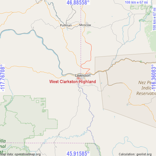
West Clarkston-Highland GPS coordinates[2]
46° 24' 10.332" North, 117° 3' 50.22" West
| Map corner | latitude | longitude |
|---|---|---|
| Upper-left | 46.88558°, | -117.76708° |
| Center: | 46.40287°, | -117.06395° |
| Lower-right: | 45.91585°, | -116.36083° |
| Map W x H: | 107.8×107.8 km | = 67×67mi |
| max Lat: | 71.29058° ⇑4.4% North |
| West Clarkston-Highland: | 46.40287° |
| min Lat: | ⇓95.6% South 19.06759° |
| min Long | West Clarkston- | max Long |
| -171.73463° | -117.06395° | -66.98998° |
| W 10.2%⇐ | ⇒89.8% E |
Elevation
Elevation of West Clarkston-Highland is 288 m = 945 ft, and this is 6.8 m = 22 ft below average elevation for this country.
| Max E: |
3189 m = 10463 ft | 29.6% |
| Avg. | 294.8 m = 967 ft | |
| West Clarkston-Highland | 288 m = 945 ft | |
Min E: |
-60 m = -197 ft | 70.4% |
See also: United States elevation on elevation.city.
Geographical zone
West Clarkston-Highland is located in North temperate zone (between Tropic of Cancer and the Arctic Circle). Distance of this North polar circle is 2241.7 km =1392.9 mi to North.| Distance of | km | miles | from West Clarkston-Highland |
|---|---|---|---|
| North Pole | 4847.5 | 3012.1 | to North |
| Arctic Circle | 2241.7 | 1392.9 | to North |
| Tropic Cancer | 2553.6 | 1586.7 | to South |
| Equator | 5159.5 | 3206 | to South |


Nearby cities:
15 places around West Clarkston-Highland: (largest is in red/bold)
• Albion
45.4 km =28.2 mi,  341°
341°
• Asotin
7.2 km =4.5 mi,  170°
170°
• Clarkston
2.1 km =1.3 mi,  43°
43°
• Clarkston Heights-Vineland
2.3 km =1.4 mi,  220°
220°
• Colfax
57.8 km =35.9 mi, 336°
• Genesee
19.6 km =12.2 mi,  32°
32°
• Juliaetta
33.7 km =20.9 mi,  54°
54°
• Lapwai
19.9 km =12.4 mi,  89°
89°
• Lewiston
3.9 km =2.4 mi,  66°
66°
• Lewiston Orchards
7.2 km =4.5 mi,  110°
110°
• Moscow
37 km =23 mi,  7°
7°
• Palouse
56.4 km =35 mi,  359°
359°
• Pomeroy
42 km =26.1 mi,  280°
280°
• Pullman
37.6 km =23.4 mi,  346°
346°
• Troy
43.4 km =27 mi, 31°
Sources, notices
• [Note1] Compared only with cities in United States existing in our database
• [Src1] Map data: © OpenStreetMap contributors (CC-BY-SA)
• [Src2] Other city data from geonames.org with taken over terms of usage.
• [Src3] Geographical zone / Annual Mean Temperature by Robert A. Rohde @ Wikipedia
