Pomeroy geodata
Pomeroy (Washington) is a seat of a second-order administrative division; located in United States in America/Los_Angeles (GMT-7) time zone. With population of 1,389 people, there are 14162 cities with bigger population in this country. Compared to other cities in United States, 95.8% of cities are located further ↓South; 90.4% of cities are located further →East and 89.1% of cities have lower elevation than Pomeroy. Note1


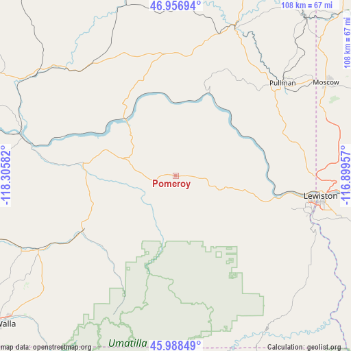
Pomeroy GPS coordinates[2]
46° 28' 29.532" North, 117° 36' 9.684" West
| Map corner | latitude | longitude |
|---|---|---|
| Upper-left | 46.95694°, | -118.30582° |
| Center: | 46.47487°, | -117.60269° |
| Lower-right: | 45.98849°, | -116.89957° |
| Map W x H: | 107.7×107.7 km | = 66.9×66.9mi |
| max Lat: | 71.29058° ⇑4.2% North |
| Pomeroy: | 46.47487° |
| min Lat: | ⇓95.8% South 19.06759° |
| min Long | Pomeroy | max Long |
| -171.73463° | -117.60269° | -66.98998° |
| W 9.6%⇐ | ⇒90.4% E |
Elevation
Elevation of Pomeroy is 565 m = 1854 ft, and this is 270.2 m = 886 ft above average elevation for this country.
| Max E: |
3189 m = 10463 ft | 10.9% |
| Pomeroy | 565 m 1854 ft | |
| Avg. | 294.8 m = 967 ft | |
Min E: |
-60 m = -197 ft | 89.1% |
See also: United States elevation on elevation.city.
Geographical zone
Pomeroy is located in North temperate zone (between Tropic of Cancer and the Arctic Circle). Distance of this North polar circle is 2233.7 km =1388 mi to North.| Distance of | km | miles | from Pomeroy |
|---|---|---|---|
| North Pole | 4839.5 | 3007.1 | to North |
| Arctic Circle | 2233.7 | 1388 | to North |
| Tropic Cancer | 2561.6 | 1591.7 | to South |
| Equator | 5167.5 | 3210.9 | to South |


Nearby cities:
15 places around Pomeroy: (largest is in red/bold)
• Albion
44.3 km =27.5 mi,  37°
37°
• Asotin
45.1 km =28 mi,  109°
109°
• Clarkston
43.2 km =26.8 mi,  98°
98°
• Clarkston Heights-Vineland
41 km =25.5 mi, 103°
• Colfax
48.6 km =30.2 mi,  21°
21°
• Dayton
33 km =20.5 mi,  239°
239°
• Genesee
52.5 km =32.6 mi,  80°
80°
• Lapwai
61.6 km =38.3 mi, 97°
• Lewiston
45.3 km =28.1 mi, 98°
• Lewiston Orchards
49.2 km =30.6 mi, 102°
• Moscow
54.2 km =33.7 mi,  58°
58°
• Palouse
62.9 km =39.1 mi, 39°
• Pullman
43.1 km =26.8 mi,  48°
48°
• Waitsburg
48 km =29.8 mi, 241°
• West Clarkston-Highland
42 km =26.1 mi, 100°
Sources, notices
• [Note1] Compared only with cities in United States existing in our database
• [Src1] Map data: © OpenStreetMap contributors (CC-BY-SA)
• [Src2] Other city data from geonames.org with taken over terms of usage.
• [Src3] Geographical zone / Annual Mean Temperature by Robert A. Rohde @ Wikipedia
