Waihee-Waiehu geodata
Waihee-Waiehu (Hawaii) is a populated place; located in United States in Pacific/Honolulu (GMT-10) time zone. With population of 8,841 people, there are 4867 cities with bigger population in this country. Compared to other cities in United States, 99.7% of cities are located further ↑North; 99.4% of cities are located further →East and 86.6% of cities have higher elevation than Waihee-Waiehu. Note1


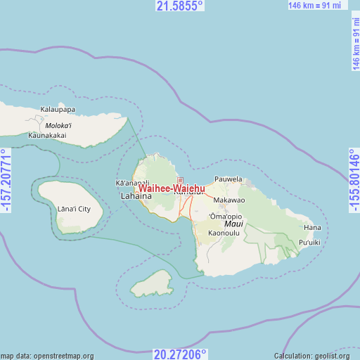
Waihee-Waiehu GPS coordinates[2]
20° 55' 48.792" North, 156° 30' 16.488" West
| Map corner | latitude | longitude |
|---|---|---|
| Upper-left | 21.5855°, | -157.20771° |
| Center: | 20.93022°, | -156.50458° |
| Lower-right: | 20.27206°, | -155.80146° |
| Map W x H: | 146×146 km | = 90.7×90.7mi |
| max Lat: | 71.29058° ⇑99.7% North |
| Waihee-Waiehu: | 20.93022° |
| min Lat: | ⇓0.3% South 19.06759° |
| min Long | Waihee-Waiehu | max Long |
| -171.73463° | -156.50458° | -66.98998° |
| W 0.6%⇐ | ⇒99.4% E |
Elevation
Elevation of Waihee-Waiehu is 24 m = 79 ft, and this is 270.8 m = 888 ft below average elevation for this country.
| Max E: |
3189 m = 10463 ft | 86.6% |
| Avg. | 294.8 m = 967 ft | |
| Waihee-Waiehu | 24 m = 79 ft | |
Min E: |
-60 m = -197 ft | 13.4% |
See also: United States elevation on elevation.city.
Geographical zone
Waihee-Waiehu is located in North Torrid zone (between Equator and Tropic of Cancer). Distance of this Northern Tropic circle is 278.7 km =173.2 mi to North.| Distance of | km | miles | from Waihee-Waiehu |
|---|---|---|---|
| North Pole | 7679.8 | 4772 | to North |
| Arctic Circle | 5074 | 3152.8 | to North |
| Tropic Cancer | 278.7 | 173.2 | to North |
| Equator | 2327.2 | 1446.1 | to South |


Nearby cities:
15 places around Waihee-Waiehu: (largest is in red/bold)
• Haiku-Pauwela
20.7 km =12.9 mi,  92°
92°
• Haliimaile
17.8 km =11.1 mi,  111°
111°
• Kaanapali Landing
19 km =11.8 mi,  270°
270°
• Kahului
5.5 km =3.4 mi,  145°
145°
• Kula
24.1 km =15 mi,  130°
130°
• Kā‘anapali
19.7 km =12.2 mi, 269°
• Kīhei
19.4 km =12.1 mi,  161°
161°
• Lahaina
18.9 km =11.7 mi,  250°
250°
• Launiupoko
16.5 km =10.3 mi,  237°
237°
• Makawao
21.5 km =13.4 mi, 112°
• Napili-Honokowai
18.7 km =11.6 mi,  285°
285°
• Paia
14.4 km =8.9 mi,  102°
102°
• Pukalani
20.3 km =12.6 mi,  120°
120°
• Waikapū
8 km =5 mi,  181°
181°
• Wailuku
4.3 km =2.7 mi, 182°
Sources, notices
• [Note1] Compared only with cities in United States existing in our database
• [Src1] Map data: © OpenStreetMap contributors (CC-BY-SA)
• [Src2] Other city data from geonames.org with taken over terms of usage.
• [Src3] Geographical zone / Annual Mean Temperature by Robert A. Rohde @ Wikipedia
