Kula geodata
Kula (Hawaii) is a populated place; located in United States in Pacific/Honolulu (GMT-10) time zone. With population of 6,452 people, there are 6140 cities with bigger population in this country. Compared to other cities in United States, 99.8% of cities are located further ↑North; 99.4% of cities are located further →East and 91% of cities have lower elevation than Kula. Note1


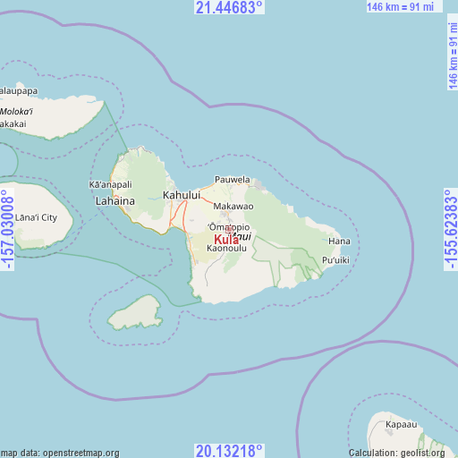
Kula GPS coordinates[2]
20° 47' 27.384" North, 156° 19' 37.02" West
| Map corner | latitude | longitude |
|---|---|---|
| Upper-left | 21.44683°, | -157.03008° |
| Center: | 20.79094°, | -156.32695° |
| Lower-right: | 20.13218°, | -155.62383° |
| Map W x H: | 146.2×146.2 km | = 90.8×90.8mi |
| max Lat: | 71.29058° ⇑99.8% North |
| Kula: | 20.79094° |
| min Lat: | ⇓0.2% South 19.06759° |
| min Long | Kula | max Long |
| -171.73463° | -156.32695° | -66.98998° |
| W 0.6%⇐ | ⇒99.4% E |
Elevation
Elevation of Kula is 704 m = 2310 ft, and this is 409.2 m = 1343 ft above average elevation for this country.
| Max E: |
3189 m = 10463 ft | 9% |
| Kula | 704 m 2310 ft | |
| Avg. | 294.8 m = 967 ft | |
Min E: |
-60 m = -197 ft | 91% |
See also: United States elevation on elevation.city.
Geographical zone
Kula is located in North Torrid zone (between Equator and Tropic of Cancer). Distance of this Northern Tropic circle is 294.2 km =182.8 mi to North.| Distance of | km | miles | from Kula |
|---|---|---|---|
| North Pole | 7695.3 | 4781.6 | to North |
| Arctic Circle | 5089.4 | 3162.4 | to North |
| Tropic Cancer | 294.2 | 182.8 | to North |
| Equator | 2311.7 | 1436.4 | to South |


Nearby cities:
15 places around Kula: (largest is in red/bold)
• Haiku-Pauwela
14.7 km =9.1 mi,  8°
8°
• Haliimaile
9.2 km =5.7 mi,  347°
347°
• Hana
35.2 km =21.9 mi,  95°
95°
• Kahului
18.8 km =11.7 mi,  305°
305°
• Kēōkea
9.8 km =6.1 mi,  197°
197°
• Kīhei
12.7 km =7.9 mi,  256°
256°
• Launiupoko
33 km =20.5 mi,  281°
281°
• Makawao
7.5 km =4.7 mi, 11°
• Paia
13.3 km =8.3 mi,  340°
340°
• Pukalani
5.2 km =3.2 mi, 348°
• Waihee-Waiehu
24.1 km =15 mi, 310°
• Waikapū
20.1 km =12.5 mi,  291°
291°
• Wailea
16.4 km =10.2 mi,  226°
226°
• Wailua
20.8 km =12.9 mi,  72°
72°
• Wailuku
21.7 km =13.5 mi,  300°
300°
Sources, notices
• [Note1] Compared only with cities in United States existing in our database
• [Src1] Map data: © OpenStreetMap contributors (CC-BY-SA)
• [Src2] Other city data from geonames.org with taken over terms of usage.
• [Src3] Geographical zone / Annual Mean Temperature by Robert A. Rohde @ Wikipedia
