Shorewood Forest geodata
Shorewood Forest (Indiana) is a populated place; located in United States in America/Chicago (GMT-5) time zone. With population of 2,708 people, there are 10166 cities with bigger population in this country. Compared to other cities in United States, 70.5% of cities are located further ↓South; 50% of cities are located further ←West and 55.4% of cities have lower elevation than Shorewood Forest. Note1


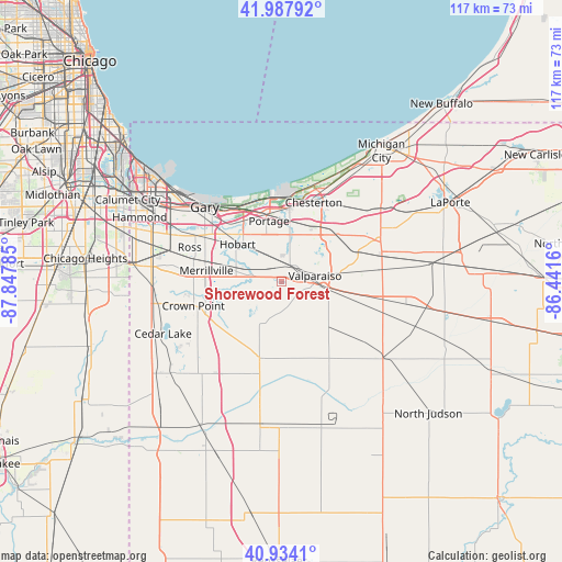
Shorewood Forest GPS coordinates[2]
41° 27' 47.34" North, 87° 8' 40.992" West
| Map corner | latitude | longitude |
|---|---|---|
| Upper-left | 41.98792°, | -87.84785° |
| Center: | 41.46315°, | -87.14472° |
| Lower-right: | 40.9341°, | -86.4416° |
| Map W x H: | 117.2×117.2 km | = 72.8×72.8mi |
| max Lat: | 71.29058° ⇑29.5% North |
| Shorewood Forest: | 41.46315° |
| min Lat: | ⇓70.5% South 19.06759° |
| min Long | Shorewood Fores | max Long |
| -171.73463° | -87.14472° | -66.98998° |
| W 50%⇐ | ⇒50% E |
Elevation
Elevation of Shorewood Forest is 220 m = 722 ft, and this is 74.8 m = 245 ft below average elevation for this country.
| Max E: |
3189 m = 10463 ft | 44.6% |
| Avg. | 294.8 m = 967 ft | |
| Shorewood Forest | 220 m = 722 ft | |
Min E: |
-60 m = -197 ft | 55.4% |
See also: United States elevation on elevation.city.
Geographical zone
Shorewood Forest is located in North temperate zone (between Tropic of Cancer and the Arctic Circle). Distance of this Northern Tropic circle is 2004.4 km =1245.5 mi to South.| Distance of | km | miles | from Shorewood Forest |
|---|---|---|---|
| North Pole | 5396.8 | 3353.4 | to North |
| Arctic Circle | 2790.9 | 1734.2 | to North |
| Tropic Cancer | 2004.4 | 1245.5 | to South |
| Equator | 4610.3 | 2864.7 | to South |


Nearby cities:
15 places around Shorewood Forest: (largest is in red/bold)
• Aberdeen
3.9 km =2.4 mi,  134°
134°
• Burns Harbor
18.1 km =11.2 mi,  2°
2°
• Chesterton
17.7 km =11 mi,  22°
22°
• Hebron
16.7 km =10.4 mi,  196°
196°
• Hobart
12 km =7.5 mi,  309°
309°
• Lake Station
14.7 km =9.1 mi,  327°
327°
• Lakes of the Four Seasons
8.2 km =5.1 mi,  224°
224°
• Merrillville
15.8 km =9.8 mi,  277°
277°
• New Chicago
15.1 km =9.4 mi, 314°
• Ogden Dunes
18.2 km =11.3 mi,  347°
347°
• Portage
12.8 km =8 mi, 348°
• Porter
17.9 km =11.1 mi, 19°
• South Haven
8.8 km =5.5 mi, 4°
• Valparaiso
7.1 km =4.4 mi,  80°
80°
• Winfield
12.6 km =7.8 mi,  239°
239°
Sources, notices
• [Note1] Compared only with cities in United States existing in our database
• [Src1] Map data: © OpenStreetMap contributors (CC-BY-SA)
• [Src2] Other city data from geonames.org with taken over terms of usage.
• [Src3] Geographical zone / Annual Mean Temperature by Robert A. Rohde @ Wikipedia
