Merrillville geodata
Merrillville (Indiana) is a populated place; located in United States in America/Chicago (GMT-5) time zone. With population of 35,224 people, there are 1399 cities with bigger population in this country. Compared to other cities in United States, 70.7% of cities are located further ↓South; 50.4% of cities are located further →East and 51.2% of cities have lower elevation than Merrillville. Note1


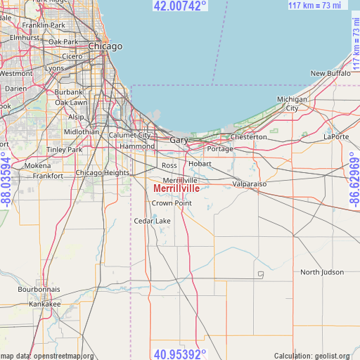
Merrillville GPS coordinates[2]
41° 28' 58.116" North, 87° 19' 58.116" West
| Map corner | latitude | longitude |
|---|---|---|
| Upper-left | 42.00742°, | -88.03594° |
| Center: | 41.48281°, | -87.33281° |
| Lower-right: | 40.95392°, | -86.62969° |
| Map W x H: | 117.1×117.1 km | = 72.8×72.8mi |
| max Lat: | 71.29058° ⇑29.3% North |
| Merrillville: | 41.48281° |
| min Lat: | ⇓70.7% South 19.06759° |
| min Long | Merrillville | max Long |
| -171.73463° | -87.33281° | -66.98998° |
| W 49.6%⇐ | ⇒50.4% E |
Elevation
Elevation of Merrillville is 203 m = 666 ft, and this is 91.8 m = 301 ft below average elevation for this country.
| Max E: |
3189 m = 10463 ft | 48.8% |
| Avg. | 294.8 m = 967 ft | |
| Merrillville | 203 m = 666 ft | |
Min E: |
-60 m = -197 ft | 51.2% |
See also: United States elevation on elevation.city.
Geographical zone
Merrillville is located in North temperate zone (between Tropic of Cancer and the Arctic Circle). Distance of this Northern Tropic circle is 2006.5 km =1246.8 mi to South.| Distance of | km | miles | from Merrillville |
|---|---|---|---|
| North Pole | 5394.6 | 3352 | to North |
| Arctic Circle | 2788.7 | 1732.8 | to North |
| Tropic Cancer | 2006.5 | 1246.8 | to South |
| Equator | 4612.5 | 2866.1 | to South |


Nearby cities:
15 places around Merrillville: (largest is in red/bold)
• Cedar Lake
15.9 km =9.9 mi,  214°
214°
• Crown Point
7.8 km =4.8 mi,  200°
200°
• Dyer
15.8 km =9.8 mi,  274°
274°
• Gary
12.3 km =7.6 mi,  354°
354°
• Griffith
9.1 km =5.7 mi,  303°
303°
• Highland
12.7 km =7.9 mi,  308°
308°
• Hobart
8.5 km =5.3 mi,  49°
49°
• Lake Station
12.9 km =8 mi,  37°
37°
• Lakes of the Four Seasons
12.8 km =8 mi,  128°
128°
• New Chicago
9.7 km =6 mi,  30°
30°
• Portage
16.6 km =10.3 mi, 51°
• Saint John
12 km =7.5 mi,  252°
252°
• Schererville
10.2 km =6.3 mi, 267°
• Shorewood Forest
15.8 km =9.8 mi,  97°
97°
• Winfield
9.9 km =6.2 mi,  150°
150°
Sources, notices
• [Note1] Compared only with cities in United States existing in our database
• [Src1] Map data: © OpenStreetMap contributors (CC-BY-SA)
• [Src2] Other city data from geonames.org with taken over terms of usage.
• [Src3] Geographical zone / Annual Mean Temperature by Robert A. Rohde @ Wikipedia
