Lake Station geodata
Lake Station (Indiana) is a populated place; located in United States in America/Chicago (GMT-5) time zone. With population of 12,054 people, there are 3883 cities with bigger population in this country. Compared to other cities in United States, 71.6% of cities are located further ↓South; 50.2% of cities are located further →East and 51.6% of cities have higher elevation than Lake Station. Note1


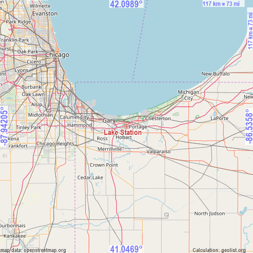
Lake Station GPS coordinates[2]
41° 34' 30.144" North, 87° 14' 20.112" West
| Map corner | latitude | longitude |
|---|---|---|
| Upper-left | 42.0989°, | -87.94205° |
| Center: | 41.57504°, | -87.23892° |
| Lower-right: | 41.0469°, | -86.5358° |
| Map W x H: | 117×117 km | = 72.7×72.7mi |
| max Lat: | 71.29058° ⇑28.4% North |
| Lake Station: | 41.57504° |
| min Lat: | ⇓71.6% South 19.06759° |
| min Long | Lake Station | max Long |
| -171.73463° | -87.23892° | -66.98998° |
| W 49.8%⇐ | ⇒50.2% E |
Elevation
Elevation of Lake Station is 192 m = 630 ft, and this is 102.8 m = 337 ft below average elevation for this country.
| Max E: |
3189 m = 10463 ft | 51.6% |
| Avg. | 294.8 m = 967 ft | |
| Lake Station | 192 m = 630 ft | |
Min E: |
-60 m = -197 ft | 48.4% |
See also: United States elevation on elevation.city.
Geographical zone
Lake Station is located in North temperate zone (between Tropic of Cancer and the Arctic Circle). Distance of this Northern Tropic circle is 2016.8 km =1253.2 mi to South.| Distance of | km | miles | from Lake Station |
|---|---|---|---|
| North Pole | 5384.4 | 3345.7 | to North |
| Arctic Circle | 2778.5 | 1726.5 | to North |
| Tropic Cancer | 2016.8 | 1253.2 | to South |
| Equator | 4622.7 | 2872.4 | to South |


Nearby cities:
15 places around Lake Station: (largest is in red/bold)
• Aberdeen
18.5 km =11.5 mi,  144°
144°
• Burns Harbor
10.4 km =6.5 mi,  57°
57°
• Chesterton
15.1 km =9.4 mi,  74°
74°
• Gary
9.2 km =5.7 mi,  282°
282°
• Griffith
16.2 km =10.1 mi,  251°
251°
• Highland
17.9 km =11.1 mi,  262°
262°
• Hobart
4.9 km =3 mi,  195°
195°
• Lakes of the Four Seasons
18.4 km =11.4 mi,  173°
173°
• Merrillville
12.9 km =8 mi,  217°
217°
• New Chicago
3.5 km =2.2 mi,  237°
237°
• Ogden Dunes
6.6 km =4.1 mi,  36°
36°
• Portage
5.2 km =3.2 mi,  88°
88°
• Porter
14.4 km =8.9 mi, 71°
• Shorewood Forest
14.7 km =9.1 mi,  147°
147°
• South Haven
9.2 km =5.7 mi,  113°
113°
Sources, notices
• [Note1] Compared only with cities in United States existing in our database
• [Src1] Map data: © OpenStreetMap contributors (CC-BY-SA)
• [Src2] Other city data from geonames.org with taken over terms of usage.
• [Src3] Geographical zone / Annual Mean Temperature by Robert A. Rohde @ Wikipedia
