Bay Harbor geodata
Bay Harbor (Michigan) is a populated place; located in United States in America/Detroit (GMT-4) time zone. With population of 5,749 people, there are 6573 cities with bigger population in this country. Compared to other cities in United States, 93.6% of cities are located further ↓South; 55.7% of cities are located further ←West and 50.7% of cities have lower elevation than Bay Harbor. Note1


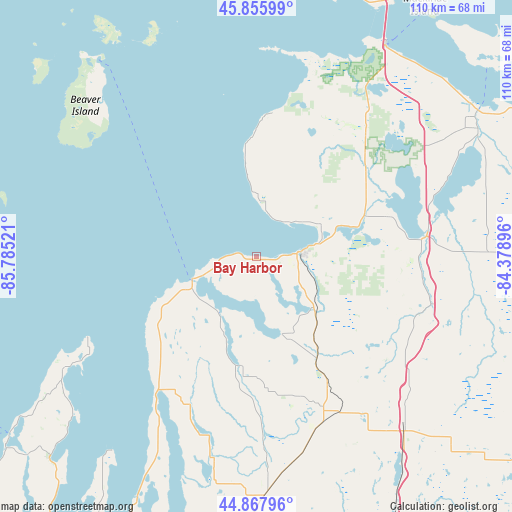
Bay Harbor GPS coordinates[2]
45° 21' 50.868" North, 85° 4' 55.488" West
| Map corner | latitude | longitude |
|---|---|---|
| Upper-left | 45.85599°, | -85.78521° |
| Center: | 45.36413°, | -85.08208° |
| Lower-right: | 44.86796°, | -84.37896° |
| Map W x H: | 109.9×109.9 km | = 68.3×68.3mi |
| max Lat: | 71.29058° ⇑6.4% North |
| Bay Harbor: | 45.36413° |
| min Lat: | ⇓93.6% South 19.06759° |
| min Long | Bay Harbor | max Long |
| -171.73463° | -85.08208° | -66.98998° |
| W 55.7%⇐ | ⇒44.3% E |
Elevation
Elevation of Bay Harbor is 201 m = 659 ft, and this is 93.8 m = 308 ft below average elevation for this country.
| Max E: |
3189 m = 10463 ft | 49.3% |
| Avg. | 294.8 m = 967 ft | |
| Bay Harbor | 201 m = 659 ft | |
Min E: |
-60 m = -197 ft | 50.7% |
See also: United States elevation on elevation.city.
Geographical zone
Bay Harbor is located in North temperate zone (between Tropic of Cancer and the Arctic Circle). Distance of this North polar circle is 2357.2 km =1464.7 mi to North.| Distance of | km | miles | from Bay Harbor |
|---|---|---|---|
| North Pole | 4963 | 3083.9 | to North |
| Arctic Circle | 2357.2 | 1464.7 | to North |
| Tropic Cancer | 2438.1 | 1515 | to South |
| Equator | 5044 | 3134.2 | to South |


Nearby cities:
15 places around Bay Harbor: (largest is in red/bold)
• Alanson
24.7 km =15.3 mi,  68°
68°
• Bay Shore
1.4 km =0.9 mi,  241°
241°
• Bellaire
43.9 km =27.3 mi,  193°
193°
• Boyne City
17.2 km =10.7 mi,  161°
161°
• Central Lake
35.7 km =22.2 mi,  203°
203°
• Charlevoix
14.7 km =9.1 mi,  249°
249°
• East Jordan
23.1 km =14.4 mi, 188°
• Gaylord
49.2 km =30.6 mi,  139°
139°
• Harbor Springs
10.3 km =6.4 mi,  43°
43°
• Horton Bay
8.9 km =5.5 mi,  178°
178°
• Indian River
37.1 km =23.1 mi,  81°
81°
• Northport
49.2 km =30.6 mi, 238°
• Pellston
31.2 km =19.4 mi,  47°
47°
• Petoskey
10 km =6.2 mi, 84°
• Vanderbilt
41.2 km =25.6 mi,  126°
126°
Sources, notices
• [Note1] Compared only with cities in United States existing in our database
• [Src1] Map data: © OpenStreetMap contributors (CC-BY-SA)
• [Src2] Other city data from geonames.org with taken over terms of usage.
• [Src3] Geographical zone / Annual Mean Temperature by Robert A. Rohde @ Wikipedia
