Manghit geodata
Manghit (Karakalpakstan) is a populated place; located in Uzbekistan in Asia/Samarkand (GMT+5) time zone. With population of 30,854 people, there are 44 cities with bigger population in this country. Compared to other cities in Uzbekistan, 90.2% of cities are located further ↓South; 92% of cities are located further →East and 90.8% of cities have higher elevation than Manghit. Note1


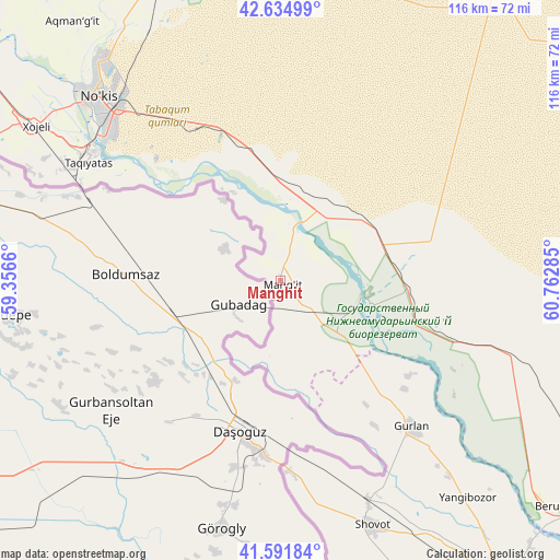
Manghit GPS coordinates[2]
42° 6' 56.016" North, 60° 3' 34.992" East
| Map corner | latitude | longitude |
|---|---|---|
| Upper-left | 42.63499°, | 59.3566° |
| Center: | 42.11556°, | 60.05972° |
| Lower-right: | 41.59184°, | 60.76285° |
| Map W x H: | 116×116 km | = 72.1×72.1mi |
| max Lat: | 43.77877° ⇑9.8% North |
| Manghit: | 42.11556° |
| min Lat: | ⇓90.2% South 37.22417° |
| min Long | Manghit | max Long |
| 58.84596° | 60.05972° | 72.76177° |
| W 8%⇐ | ⇒92% E |
Elevation
Elevation of Manghit is 85 m = 279 ft, and this is 348.8 m = 1144 ft below average elevation for this country.
| Max E: |
1464 m = 4803 ft | 90.8% |
| Avg. | 433.8 m = 1423 ft | |
| Manghit | 85 m = 279 ft | |
Min E: |
50 m = 164 ft | 9.2% |
See also: Uzbekistan elevation on elevation.city.
Geographical zone
Manghit is located in North temperate zone (between Tropic of Cancer and the Arctic Circle). Distance of this Northern Tropic circle is 2076.9 km =1290.5 mi to South.| Distance of | km | miles | from Manghit |
|---|---|---|---|
| North Pole | 5324.3 | 3308.4 | to North |
| Arctic Circle | 2718.4 | 1689.1 | to North |
| Tropic Cancer | 2076.9 | 1290.5 | to South |
| Equator | 4682.8 | 2909.8 | to South |


Nearby cities:
15 places around Manghit: (largest is in red/bold)
• Beruniy
74.3 km =46.2 mi,  129°
129°
• Beruniy Shahri
73.9 km =45.9 mi, 128°
• Bo‘ston Shahri
79.3 km =49.3 mi,  112°
112°
• Chimboy Shahri
93.3 km =58 mi,  345°
345°
• Gurlan
40.8 km =25.4 mi,  137°
137°
• Kegeyli Shahar
82.3 km =51.1 mi,  333°
333°
• Khiwa
85.8 km =53.3 mi,  162°
162°
• Khŭjayli
58.6 km =36.4 mi,  302°
302°
• Mang‘it Shahri
0.8 km =0.5 mi,  18°
18°
• Nukus
52.7 km =32.7 mi,  315°
315°
• Oqmang‘it
68.9 km =42.8 mi, 321°
• Qŭshkŭpir
68.8 km =42.8 mi, 159°
• Showot
54.9 km =34.1 mi, 158°
• Urganch
78.8 km =49 mi, 142°
• Xo‘jayli Shahri
60.2 km =37.4 mi, 302°
Sources, notices
• [Note1] Compared only with cities in Uzbekistan existing in our database
• [Src1] Map data: © OpenStreetMap contributors (CC-BY-SA)
• [Src2] Other city data from geonames.org with taken over terms of usage.
• [Src3] Geographical zone / Annual Mean Temperature by Robert A. Rohde @ Wikipedia
